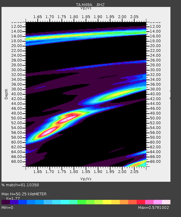
M49A Liberty Center, OH, USA - Earthquake Result Viewer
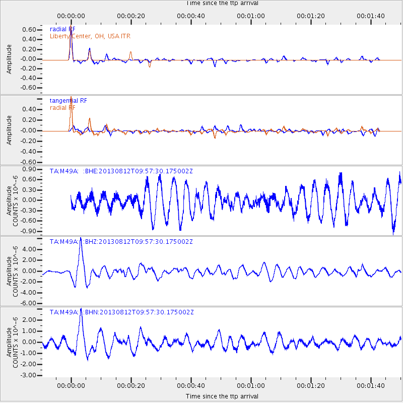
Earthquake location: Near Coast Of Northern Peru
Earthquake latitude/longitude: -5.4/-81.9
Earthquake time(UTC): 2013/08/12 (224) 09:49:32 GMT
Earthquake Depth: 10 km
Earthquake Magnitude: 6.2 MWW, 6.1 MWB, 6.2 MWW, 6.2 MWC, 6.3 MWC
Earthquake Catalog/Contributor: NEIC PDE/NEIC COMCAT
Network: TA USArray Transportable Network (new EarthScope stations)
Station: M49A Liberty Center, OH, USA
Lat/Lon: 41.47 N/83.98 W
Elevation: 203 m
Distance: 46.7 deg
Az: 357.884 deg
Baz: 177.196 deg
Ray Param: 0.070493296
Estimated Moho Depth: 50.25 km
Estimated Crust Vp/Vs: 1.77
Assumed Crust Vp: 6.498 km/s
Estimated Crust Vs: 3.671 km/s
Estimated Crust Poisson's Ratio: 0.27
Radial Match: 81.10358 %
Radial Bump: 218
Transverse Match: 65.0364 %
Transverse Bump: 400
SOD ConfigId: 626651
Insert Time: 2014-04-17 23:29:30.370 +0000
GWidth: 2.5
Max Bumps: 400
Tol: 0.001

Signal To Noise

ChannelStoNSTALTA
TA:M49A: :BHZ:20130812T09:57:30.175002Z7.4458532.6587152E-63.570733E-7
TA:M49A: :BHN:20130812T09:57:30.175002Z5.6304351.3065322E-62.3204818E-7
TA:M49A: :BHE:20130812T09:57:30.175002Z3.00415975.113137E-71.7020191E-7
Arrivals
Ps6.3 SECOND
PpPs20 SECOND
PsPs/PpSs26 SECOND