You are here: Home > Network List > TA - USArray Transportable Network (new EarthScope stations) Stations List
> Station M50A Fremont, OH, USA > Earthquake Result Viewer
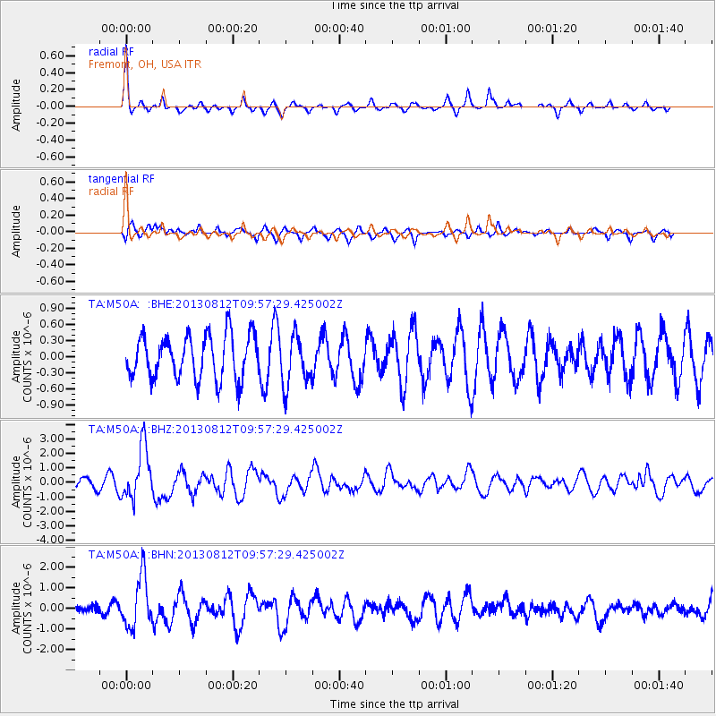
M50A Fremont, OH, USA - Earthquake Result Viewer
*The percent match for this event was below the threshold and hence no stack was calculated.
| Earthquake location: |
Near Coast Of Northern Peru |
| Earthquake latitude/longitude: |
-5.4/-81.9 |
| Earthquake time(UTC): |
2013/08/12 (224) 09:49:32 GMT |
| Earthquake Depth: |
10 km |
| Earthquake Magnitude: |
6.2 MWW, 6.1 MWB, 6.2 MWW, 6.2 MWC, 6.3 MWC |
| Earthquake Catalog/Contributor: |
NEIC PDE/NEIC COMCAT |
|
| Network: |
TA USArray Transportable Network (new EarthScope stations) |
| Station: |
M50A Fremont, OH, USA |
| Lat/Lon: |
41.40 N/83.04 W |
| Elevation: |
176 m |
|
| Distance: |
46.6 deg |
| Az: |
358.844 deg |
| Baz: |
178.47 deg |
| Ray Param: |
$rayparam |
*The percent match for this event was below the threshold and hence was not used in the summary stack. |
|
| Radial Match: |
73.60515 % |
| Radial Bump: |
298 |
| Transverse Match: |
64.48012 % |
| Transverse Bump: |
359 |
| SOD ConfigId: |
626651 |
| Insert Time: |
2014-04-17 23:29:38.707 +0000 |
| GWidth: |
2.5 |
| Max Bumps: |
400 |
| Tol: |
0.001 |
|
Signal To Noise
| Channel | StoN | STA | LTA |
| TA:M50A: :BHZ:20130812T09:57:29.425002Z | 5.8876843 | 1.8223615E-6 | 3.095209E-7 |
| TA:M50A: :BHN:20130812T09:57:29.425002Z | 7.09385 | 1.2532932E-6 | 1.7667321E-7 |
| TA:M50A: :BHE:20130812T09:57:29.425002Z | 1.1375073 | 4.630526E-7 | 4.0707658E-7 |
| Arrivals |
| Ps | |
| PpPs | |
| PsPs/PpSs | |


