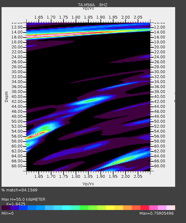
M56A Emporium, PA, USA - Earthquake Result Viewer
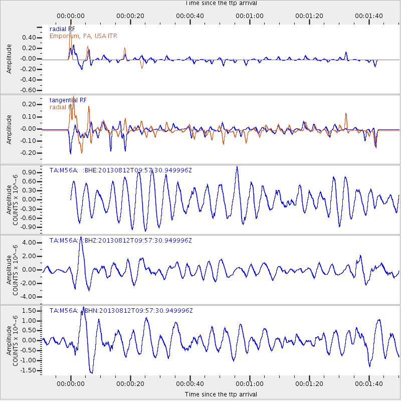
Earthquake location: Near Coast Of Northern Peru
Earthquake latitude/longitude: -5.4/-81.9
Earthquake time(UTC): 2013/08/12 (224) 09:49:32 GMT
Earthquake Depth: 10 km
Earthquake Magnitude: 6.2 MWW, 6.1 MWB, 6.2 MWW, 6.2 MWC, 6.3 MWC
Earthquake Catalog/Contributor: NEIC PDE/NEIC COMCAT
Network: TA USArray Transportable Network (new EarthScope stations)
Station: M56A Emporium, PA, USA
Lat/Lon: 41.48 N/78.18 W
Elevation: 493 m
Distance: 46.8 deg
Az: 3.861 deg
Baz: 185.119 deg
Ray Param: 0.070429
Estimated Moho Depth: 55.0 km
Estimated Crust Vp/Vs: 1.64
Assumed Crust Vp: 6.121 km/s
Estimated Crust Vs: 3.726 km/s
Estimated Crust Poisson's Ratio: 0.21
Radial Match: 84.1569 %
Radial Bump: 273
Transverse Match: 63.219193 %
Transverse Bump: 383
SOD ConfigId: 626651
Insert Time: 2014-04-17 23:29:55.660 +0000
GWidth: 2.5
Max Bumps: 400
Tol: 0.001

Signal To Noise

ChannelStoNSTALTA
TA:M56A: :BHZ:20130812T09:57:30.949996Z4.68204162.3000891E-64.912577E-7
TA:M56A: :BHN:20130812T09:57:30.949996Z2.13365348.210592E-73.8481375E-7
TA:M56A: :BHE:20130812T09:57:30.949996Z1.19798225.7236156E-74.777714E-7
Arrivals
Ps6.1 SECOND
PpPs22 SECOND
PsPs/PpSs28 SECOND