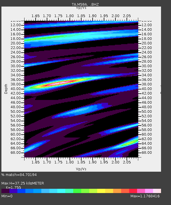
M59A Waymart, PA, USA - Earthquake Result Viewer
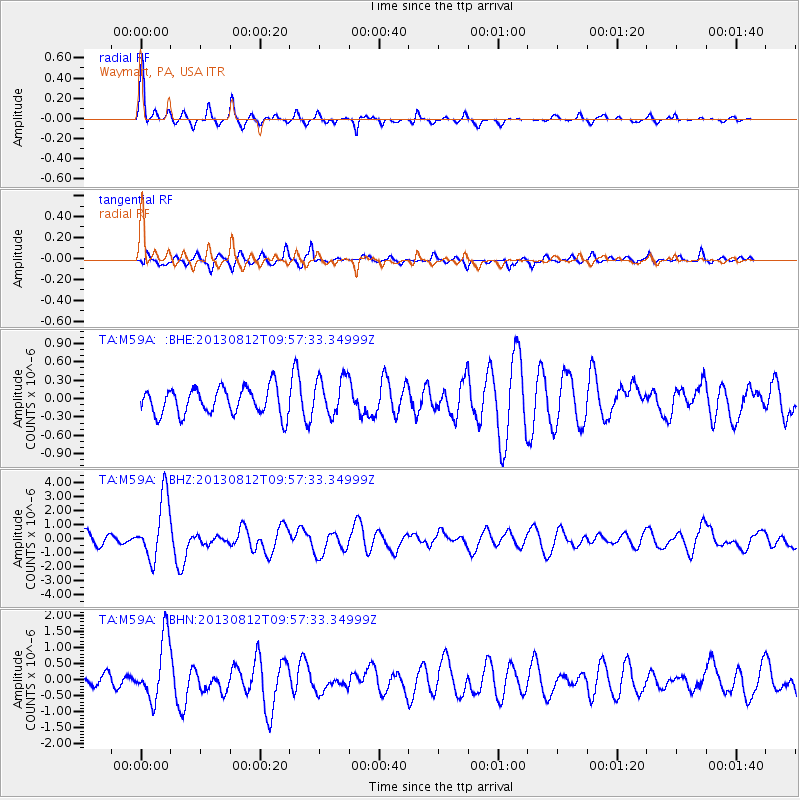
Earthquake location: Near Coast Of Northern Peru
Earthquake latitude/longitude: -5.4/-81.9
Earthquake time(UTC): 2013/08/12 (224) 09:49:32 GMT
Earthquake Depth: 10 km
Earthquake Magnitude: 6.2 MWW, 6.1 MWB, 6.2 MWW, 6.2 MWC, 6.3 MWC
Earthquake Catalog/Contributor: NEIC PDE/NEIC COMCAT
Network: TA USArray Transportable Network (new EarthScope stations)
Station: M59A Waymart, PA, USA
Lat/Lon: 41.54 N/75.43 W
Elevation: 471 m
Distance: 47.1 deg
Az: 6.658 deg
Baz: 188.845 deg
Ray Param: 0.070223615
Estimated Moho Depth: 37.25 km
Estimated Crust Vp/Vs: 1.75
Assumed Crust Vp: 6.283 km/s
Estimated Crust Vs: 3.58 km/s
Estimated Crust Poisson's Ratio: 0.26
Radial Match: 84.70194 %
Radial Bump: 307
Transverse Match: 80.551186 %
Transverse Bump: 353
SOD ConfigId: 626651
Insert Time: 2014-04-17 23:29:59.381 +0000
GWidth: 2.5
Max Bumps: 400
Tol: 0.001

Signal To Noise

ChannelStoNSTALTA
TA:M59A: :BHZ:20130812T09:57:33.34999Z4.9434462.196935E-64.4441367E-7
TA:M59A: :BHN:20130812T09:57:33.34999Z6.12846669.704697E-71.5835441E-7
TA:M59A: :BHE:20130812T09:57:33.34999Z1.45993923.2058813E-72.1959006E-7
Arrivals
Ps4.8 SECOND
PpPs15 SECOND
PsPs/PpSs20 SECOND