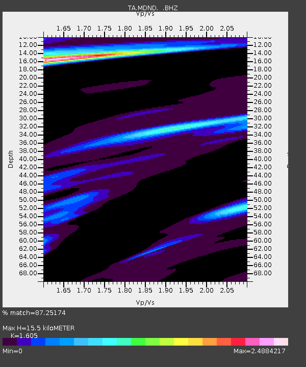
MDND Maddock, ND, USA - Earthquake Result Viewer

Earthquake location: Near Coast Of Northern Peru
Earthquake latitude/longitude: -5.4/-81.9
Earthquake time(UTC): 2013/08/12 (224) 09:49:32 GMT
Earthquake Depth: 10 km
Earthquake Magnitude: 6.2 MWW, 6.1 MWB, 6.2 MWW, 6.2 MWC, 6.3 MWC
Earthquake Catalog/Contributor: NEIC PDE/NEIC COMCAT
Network: TA USArray Transportable Network (new EarthScope stations)
Station: MDND Maddock, ND, USA
Lat/Lon: 47.85 N/99.60 W
Elevation: 479 m
Distance: 55.3 deg
Az: 345.588 deg
Baz: 158.414 deg
Ray Param: 0.06491331
Estimated Moho Depth: 15.5 km
Estimated Crust Vp/Vs: 1.61
Assumed Crust Vp: 6.53 km/s
Estimated Crust Vs: 4.069 km/s
Estimated Crust Poisson's Ratio: 0.18
Radial Match: 87.25174 %
Radial Bump: 387
Transverse Match: 76.24844 %
Transverse Bump: 400
SOD ConfigId: 626651
Insert Time: 2014-04-17 23:30:08.411 +0000
GWidth: 2.5
Max Bumps: 400
Tol: 0.001

Signal To Noise

ChannelStoNSTALTA
TA:MDND: :BHZ:20130812T09:58:34.575027Z14.0919624.634839E-63.288995E-7
TA:MDND: :BHN:20130812T09:58:34.575027Z1.2811912.1454862E-61.6746028E-6
TA:MDND: :BHE:20130812T09:58:34.575027Z0.629171137.003226E-71.1130876E-6
Arrivals
Ps1.5 SECOND
PpPs5.8 SECOND
PsPs/PpSs7.3 SECOND