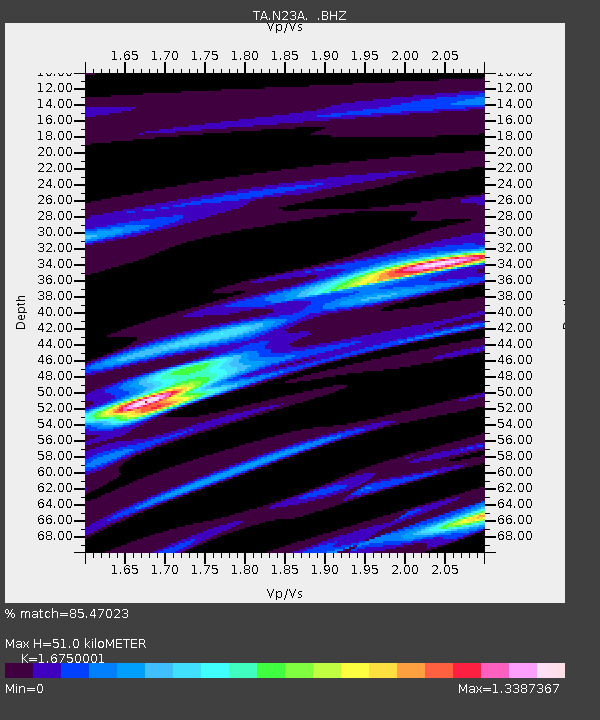
N23A Red Feather Lakes, CO, USA - Earthquake Result Viewer
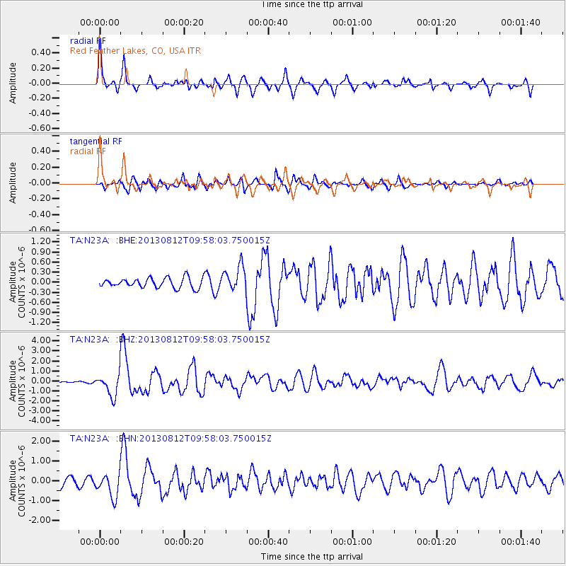
Earthquake location: Near Coast Of Northern Peru
Earthquake latitude/longitude: -5.4/-81.9
Earthquake time(UTC): 2013/08/12 (224) 09:49:32 GMT
Earthquake Depth: 10 km
Earthquake Magnitude: 6.2 MWW, 6.1 MWB, 6.2 MWW, 6.2 MWC, 6.3 MWC
Earthquake Catalog/Contributor: NEIC PDE/NEIC COMCAT
Network: TA USArray Transportable Network (new EarthScope stations)
Station: N23A Red Feather Lakes, CO, USA
Lat/Lon: 40.89 N/105.94 W
Elevation: 2458 m
Distance: 51.1 deg
Az: 336.629 deg
Baz: 148.601 deg
Ray Param: 0.06765012
Estimated Moho Depth: 51.0 km
Estimated Crust Vp/Vs: 1.68
Assumed Crust Vp: 6.306 km/s
Estimated Crust Vs: 3.765 km/s
Estimated Crust Poisson's Ratio: 0.22
Radial Match: 85.47023 %
Radial Bump: 400
Transverse Match: 85.743774 %
Transverse Bump: 400
SOD ConfigId: 626651
Insert Time: 2014-04-17 23:30:13.566 +0000
GWidth: 2.5
Max Bumps: 400
Tol: 0.001

Signal To Noise

ChannelStoNSTALTA
TA:N23A: :BHZ:20130812T09:58:03.750015Z12.773911.1689689E-69.151222E-8
TA:N23A: :BHN:20130812T09:58:03.750015Z3.2462556.209854E-71.9129287E-7
TA:N23A: :BHE:20130812T09:58:03.750015Z2.60563683.8304125E-71.4700485E-7
Arrivals
Ps5.8 SECOND
PpPs20 SECOND
PsPs/PpSs26 SECOND