You are here: Home > Network List > TA - USArray Transportable Network (new EarthScope stations) Stations List
> Station N40A Mertquake, Salem, IA, USA > Earthquake Result Viewer
N40A Mertquake, Salem, IA, USA - Earthquake Result Viewer
| Earthquake location: |
Near Coast Of Northern Peru |
| Earthquake latitude/longitude: |
-5.4/-81.9 |
| Earthquake time(UTC): |
2013/08/12 (224) 09:49:32 GMT |
| Earthquake Depth: |
10 km |
| Earthquake Magnitude: |
6.2 MWW, 6.1 MWB, 6.2 MWW, 6.2 MWC, 6.3 MWC |
| Earthquake Catalog/Contributor: |
NEIC PDE/NEIC COMCAT |
|
| Network: |
TA USArray Transportable Network (new EarthScope stations) |
| Station: |
N40A Mertquake, Salem, IA, USA |
| Lat/Lon: |
40.88 N/91.58 W |
| Elevation: |
208 m |
|
| Distance: |
46.9 deg |
| Az: |
349.968 deg |
| Baz: |
166.777 deg |
| Ray Param: |
0.070348695 |
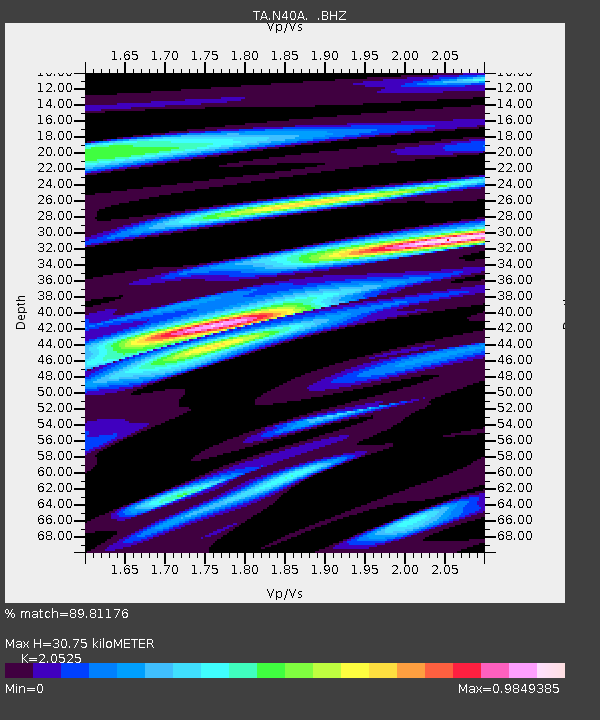
| Estimated Moho Depth: |
30.75 km |
| Estimated Crust Vp/Vs: |
2.05 |
| Assumed Crust Vp: |
6.498 km/s |
| Estimated Crust Vs: |
3.166 km/s |
| Estimated Crust Poisson's Ratio: |
0.34 |
|
| Radial Match: |
89.81176 % |
| Radial Bump: |
400 |
| Transverse Match: |
55.302765 % |
| Transverse Bump: |
400 |
| SOD ConfigId: |
626651 |
| Insert Time: |
2014-04-17 23:30:20.393 +0000 |
| GWidth: |
2.5 |
| Max Bumps: |
400 |
| Tol: |
0.001 |
|
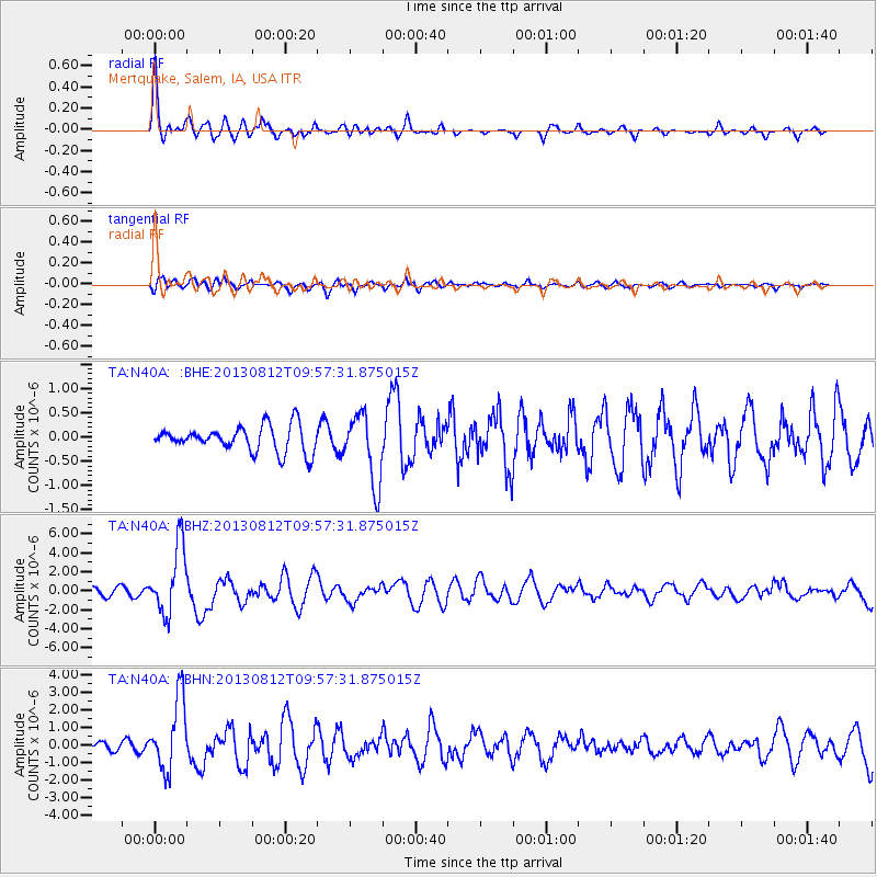
Signal To Noise
| Channel | StoN | STA | LTA |
| TA:N40A: :BHZ:20130812T09:57:31.875015Z | 10.992118 | 3.5745848E-6 | 3.2519526E-7 |
| TA:N40A: :BHN:20130812T09:57:31.875015Z | 8.967465 | 2.0343698E-6 | 2.2686119E-7 |
| TA:N40A: :BHE:20130812T09:57:31.875015Z | 2.724615 | 7.193937E-7 | 2.64035E-7 |
| Arrivals |
| Ps | 5.3 SECOND |
| PpPs | 14 SECOND |
| PsPs/PpSs | 19 SECOND |


