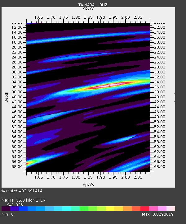
N48A Decatur, IN, USA - Earthquake Result Viewer

Earthquake location: Near Coast Of Northern Peru
Earthquake latitude/longitude: -5.4/-81.9
Earthquake time(UTC): 2013/08/12 (224) 09:49:32 GMT
Earthquake Depth: 10 km
Earthquake Magnitude: 6.2 MWW, 6.1 MWB, 6.2 MWW, 6.2 MWC, 6.3 MWC
Earthquake Catalog/Contributor: NEIC PDE/NEIC COMCAT
Network: TA USArray Transportable Network (new EarthScope stations)
Station: N48A Decatur, IN, USA
Lat/Lon: 40.86 N/85.03 W
Elevation: 250 m
Distance: 46.1 deg
Az: 356.737 deg
Baz: 175.715 deg
Ray Param: 0.07084316
Estimated Moho Depth: 35.0 km
Estimated Crust Vp/Vs: 1.93
Assumed Crust Vp: 6.498 km/s
Estimated Crust Vs: 3.358 km/s
Estimated Crust Poisson's Ratio: 0.32
Radial Match: 83.691414 %
Radial Bump: 271
Transverse Match: 69.201866 %
Transverse Bump: 400
SOD ConfigId: 626651
Insert Time: 2014-04-17 23:30:24.963 +0000
GWidth: 2.5
Max Bumps: 400
Tol: 0.001

Signal To Noise

ChannelStoNSTALTA
TA:N48A: :BHZ:20130812T09:57:25.750015Z11.3441542.3079117E-62.0344503E-7
TA:N48A: :BHN:20130812T09:57:25.750015Z11.5204871.6055299E-61.3936302E-7
TA:N48A: :BHE:20130812T09:57:25.750015Z0.430232551.265325E-72.9410256E-7
Arrivals
Ps5.3 SECOND
PpPs15 SECOND
PsPs/PpSs20 SECOND