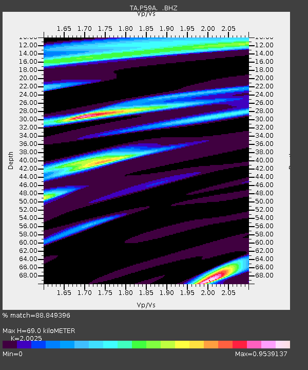
P59A Jarrettsville, MD, USA - Earthquake Result Viewer
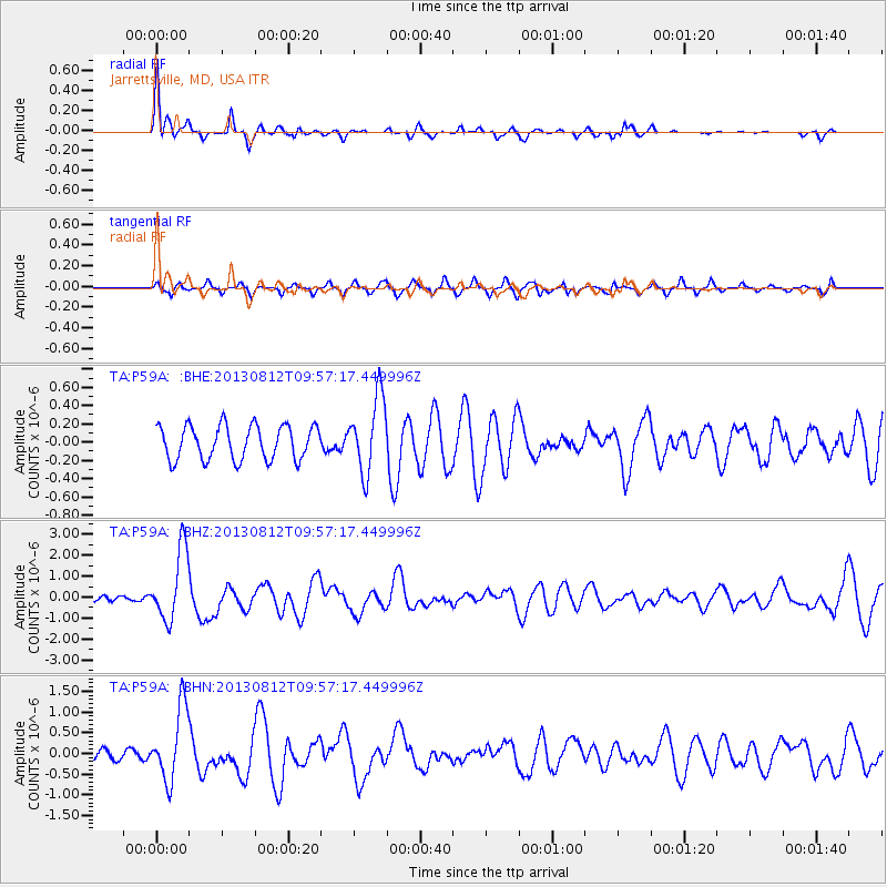
Earthquake location: Near Coast Of Northern Peru
Earthquake latitude/longitude: -5.4/-81.9
Earthquake time(UTC): 2013/08/12 (224) 09:49:32 GMT
Earthquake Depth: 10 km
Earthquake Magnitude: 6.2 MWW, 6.1 MWB, 6.2 MWW, 6.2 MWC, 6.3 MWC
Earthquake Catalog/Contributor: NEIC PDE/NEIC COMCAT
Network: TA USArray Transportable Network (new EarthScope stations)
Station: P59A Jarrettsville, MD, USA
Lat/Lon: 39.61 N/76.43 W
Elevation: 157 m
Distance: 45.1 deg
Az: 5.997 deg
Baz: 187.738 deg
Ray Param: 0.07152226
Estimated Moho Depth: 69.0 km
Estimated Crust Vp/Vs: 2.00
Assumed Crust Vp: 6.419 km/s
Estimated Crust Vs: 3.206 km/s
Estimated Crust Poisson's Ratio: 0.33
Radial Match: 88.849396 %
Radial Bump: 329
Transverse Match: 61.443954 %
Transverse Bump: 400
SOD ConfigId: 626651
Insert Time: 2014-04-17 23:32:16.092 +0000
GWidth: 2.5
Max Bumps: 400
Tol: 0.001

Signal To Noise

ChannelStoNSTALTA
TA:P59A: :BHZ:20130812T09:57:17.449996Z11.0518651.6888343E-61.528099E-7
TA:P59A: :BHN:20130812T09:57:17.449996Z6.5747588.850919E-71.3461968E-7
TA:P59A: :BHE:20130812T09:57:17.449996Z2.21386364.115655E-71.8590373E-7
Arrivals
Ps11 SECOND
PpPs31 SECOND
PsPs/PpSs42 SECOND