You are here: Home > Network List > TA - USArray Transportable Network (new EarthScope stations) Stations List
> Station Q53A Leroy, WV, USA > Earthquake Result Viewer
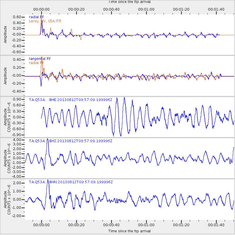
Q53A Leroy, WV, USA - Earthquake Result Viewer
*The percent match for this event was below the threshold and hence no stack was calculated.
| Earthquake location: |
Near Coast Of Northern Peru |
| Earthquake latitude/longitude: |
-5.4/-81.9 |
| Earthquake time(UTC): |
2013/08/12 (224) 09:49:32 GMT |
| Earthquake Depth: |
10 km |
| Earthquake Magnitude: |
6.2 MWW, 6.1 MWB, 6.2 MWW, 6.2 MWC, 6.3 MWC |
| Earthquake Catalog/Contributor: |
NEIC PDE/NEIC COMCAT |
|
| Network: |
TA USArray Transportable Network (new EarthScope stations) |
| Station: |
Q53A Leroy, WV, USA |
| Lat/Lon: |
38.86 N/81.53 W |
| Elevation: |
310 m |
|
| Distance: |
44.0 deg |
| Az: |
0.451 deg |
| Baz: |
180.575 deg |
| Ray Param: |
$rayparam |
*The percent match for this event was below the threshold and hence was not used in the summary stack. |
|
| Radial Match: |
73.18407 % |
| Radial Bump: |
359 |
| Transverse Match: |
55.213768 % |
| Transverse Bump: |
375 |
| SOD ConfigId: |
626651 |
| Insert Time: |
2014-04-17 23:32:39.566 +0000 |
| GWidth: |
2.5 |
| Max Bumps: |
400 |
| Tol: |
0.001 |
|
Signal To Noise
| Channel | StoN | STA | LTA |
| TA:Q53A: :BHZ:20130812T09:57:09.199996Z | 4.1110673 | 1.949689E-6 | 4.7425374E-7 |
| TA:Q53A: :BHN:20130812T09:57:09.199996Z | 3.6416705 | 1.1496497E-6 | 3.1569294E-7 |
| TA:Q53A: :BHE:20130812T09:57:09.199996Z | 0.76922315 | 2.22555E-7 | 2.8932436E-7 |
| Arrivals |
| Ps | |
| PpPs | |
| PsPs/PpSs | |


