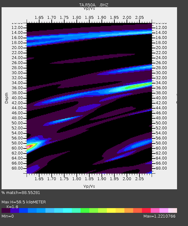
R50A Paris, KY, USA - Earthquake Result Viewer

Earthquake location: Near Coast Of Northern Peru
Earthquake latitude/longitude: -5.4/-81.9
Earthquake time(UTC): 2013/08/12 (224) 09:49:32 GMT
Earthquake Depth: 10 km
Earthquake Magnitude: 6.2 MWW, 6.1 MWB, 6.2 MWW, 6.2 MWC, 6.3 MWC
Earthquake Catalog/Contributor: NEIC PDE/NEIC COMCAT
Network: TA USArray Transportable Network (new EarthScope stations)
Station: R50A Paris, KY, USA
Lat/Lon: 38.28 N/84.33 W
Elevation: 255 m
Distance: 43.5 deg
Az: 357.256 deg
Baz: 176.527 deg
Ray Param: 0.072504885
Estimated Moho Depth: 59.5 km
Estimated Crust Vp/Vs: 1.60
Assumed Crust Vp: 6.498 km/s
Estimated Crust Vs: 4.061 km/s
Estimated Crust Poisson's Ratio: 0.18
Radial Match: 88.55281 %
Radial Bump: 380
Transverse Match: 59.089176 %
Transverse Bump: 367
SOD ConfigId: 626651
Insert Time: 2014-04-17 23:33:10.930 +0000
GWidth: 2.5
Max Bumps: 400
Tol: 0.001

Signal To Noise

ChannelStoNSTALTA
TA:R50A: :BHZ:20130812T09:57:05.025009Z11.0723861.6360511E-61.4775958E-7
TA:R50A: :BHN:20130812T09:57:05.025009Z11.8693271.0458124E-68.8110504E-8
TA:R50A: :BHE:20130812T09:57:05.025009Z1.66642812.6086025E-71.5653856E-7
Arrivals
Ps5.9 SECOND
PpPs22 SECOND
PsPs/PpSs28 SECOND