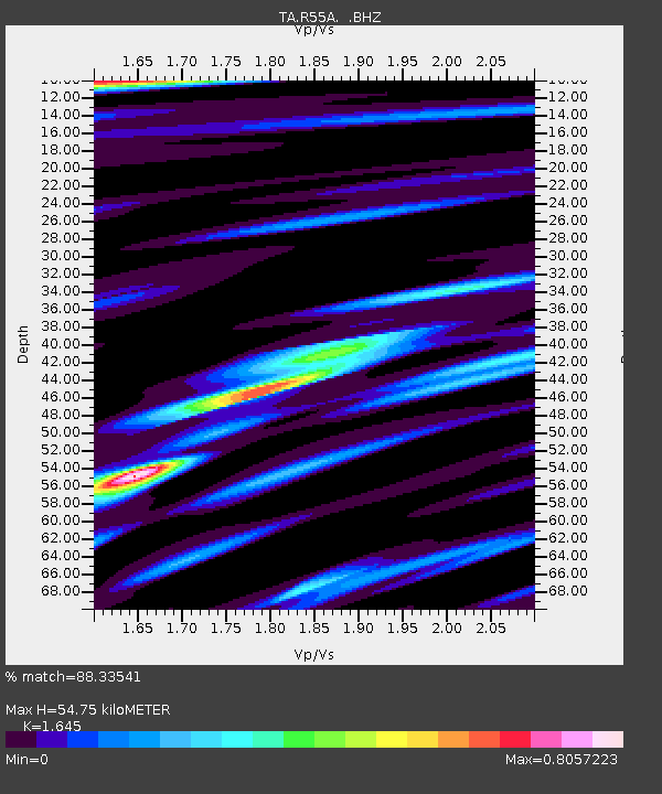
R55A Marlinton, WV, USA - Earthquake Result Viewer

Earthquake location: Near Coast Of Northern Peru
Earthquake latitude/longitude: -5.4/-81.9
Earthquake time(UTC): 2013/08/12 (224) 09:49:32 GMT
Earthquake Depth: 10 km
Earthquake Magnitude: 6.2 MWW, 6.1 MWB, 6.2 MWW, 6.2 MWC, 6.3 MWC
Earthquake Catalog/Contributor: NEIC PDE/NEIC COMCAT
Network: TA USArray Transportable Network (new EarthScope stations)
Station: R55A Marlinton, WV, USA
Lat/Lon: 38.28 N/80.12 W
Elevation: 833 m
Distance: 43.5 deg
Az: 2.067 deg
Baz: 182.615 deg
Ray Param: 0.07252024
Estimated Moho Depth: 54.75 km
Estimated Crust Vp/Vs: 1.64
Assumed Crust Vp: 6.207 km/s
Estimated Crust Vs: 3.773 km/s
Estimated Crust Poisson's Ratio: 0.21
Radial Match: 88.33541 %
Radial Bump: 400
Transverse Match: 38.709476 %
Transverse Bump: 400
SOD ConfigId: 626651
Insert Time: 2014-04-17 23:33:22.668 +0000
GWidth: 2.5
Max Bumps: 400
Tol: 0.001

Signal To Noise

ChannelStoNSTALTA
TA:R55A: :BHZ:20130812T09:57:04.824996Z7.8665971.7794489E-62.2620313E-7
TA:R55A: :BHN:20130812T09:57:04.824996Z4.92925551.044473E-62.1189267E-7
TA:R55A: :BHE:20130812T09:57:04.824996Z0.906895762.3954388E-72.6413608E-7
Arrivals
Ps6.1 SECOND
PpPs22 SECOND
PsPs/PpSs28 SECOND