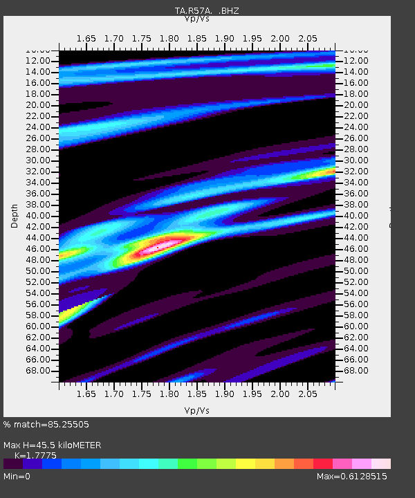
R57A Stanardsville, VA, USA - Earthquake Result Viewer

Earthquake location: Near Coast Of Northern Peru
Earthquake latitude/longitude: -5.4/-81.9
Earthquake time(UTC): 2013/08/12 (224) 09:49:32 GMT
Earthquake Depth: 10 km
Earthquake Magnitude: 6.2 MWW, 6.1 MWB, 6.2 MWW, 6.2 MWC, 6.3 MWC
Earthquake Catalog/Contributor: NEIC PDE/NEIC COMCAT
Network: TA USArray Transportable Network (new EarthScope stations)
Station: R57A Stanardsville, VA, USA
Lat/Lon: 38.30 N/78.52 W
Elevation: 230 m
Distance: 43.6 deg
Az: 3.885 deg
Baz: 184.918 deg
Ray Param: 0.07245749
Estimated Moho Depth: 45.5 km
Estimated Crust Vp/Vs: 1.78
Assumed Crust Vp: 6.159 km/s
Estimated Crust Vs: 3.465 km/s
Estimated Crust Poisson's Ratio: 0.27
Radial Match: 85.25505 %
Radial Bump: 341
Transverse Match: 63.058056 %
Transverse Bump: 400
SOD ConfigId: 626651
Insert Time: 2014-04-17 23:33:30.642 +0000
GWidth: 2.5
Max Bumps: 400
Tol: 0.001

Signal To Noise

ChannelStoNSTALTA
TA:R57A: :BHZ:20130812T09:57:05.625015Z11.5741471.805625E-61.5600502E-7
TA:R57A: :BHN:20130812T09:57:05.625015Z6.15970331.0313172E-61.6742968E-7
TA:R57A: :BHE:20130812T09:57:05.625015Z1.46233672.5460594E-71.7410898E-7
Arrivals
Ps6.1 SECOND
PpPs19 SECOND
PsPs/PpSs25 SECOND