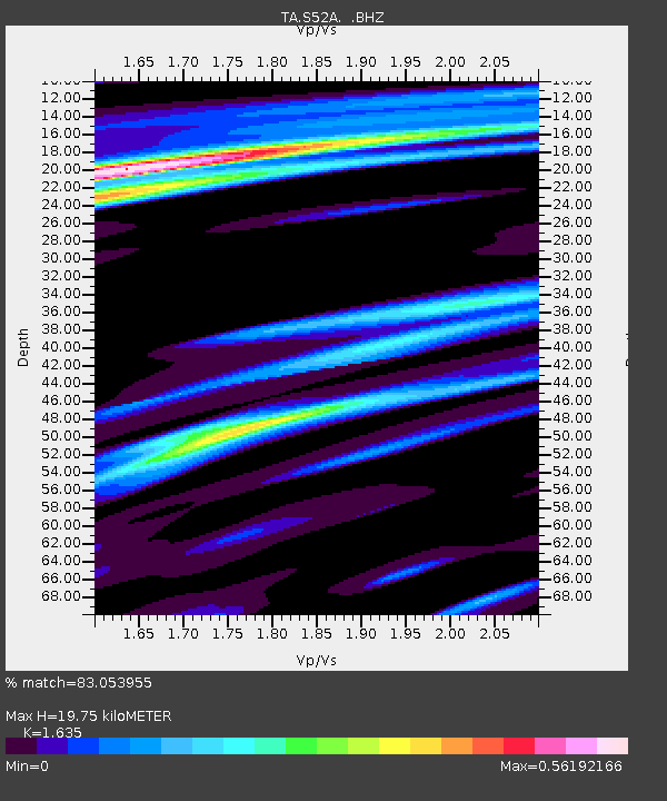
S52A Salyersville, KY, USA - Earthquake Result Viewer
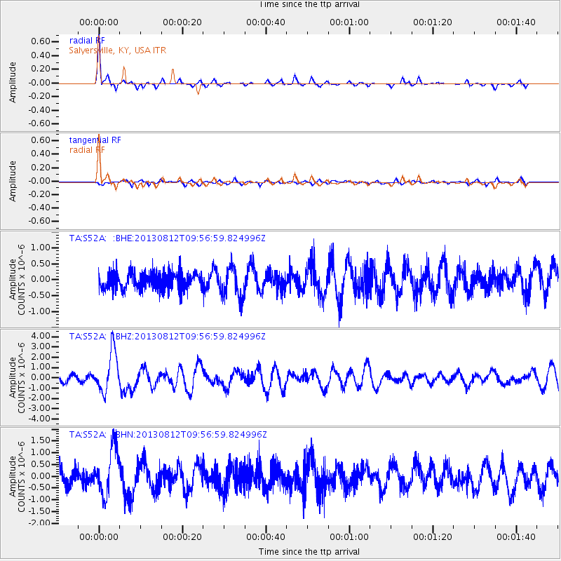
Earthquake location: Near Coast Of Northern Peru
Earthquake latitude/longitude: -5.4/-81.9
Earthquake time(UTC): 2013/08/12 (224) 09:49:32 GMT
Earthquake Depth: 10 km
Earthquake Magnitude: 6.2 MWW, 6.1 MWB, 6.2 MWW, 6.2 MWC, 6.3 MWC
Earthquake Catalog/Contributor: NEIC PDE/NEIC COMCAT
Network: TA USArray Transportable Network (new EarthScope stations)
Station: S52A Salyersville, KY, USA
Lat/Lon: 37.68 N/83.08 W
Elevation: 367 m
Distance: 42.9 deg
Az: 358.657 deg
Baz: 178.314 deg
Ray Param: 0.07291589
Estimated Moho Depth: 19.75 km
Estimated Crust Vp/Vs: 1.63
Assumed Crust Vp: 6.476 km/s
Estimated Crust Vs: 3.961 km/s
Estimated Crust Poisson's Ratio: 0.20
Radial Match: 83.053955 %
Radial Bump: 330
Transverse Match: 37.65957 %
Transverse Bump: 383
SOD ConfigId: 626651
Insert Time: 2014-04-17 23:33:59.737 +0000
GWidth: 2.5
Max Bumps: 400
Tol: 0.001

Signal To Noise

ChannelStoNSTALTA
TA:S52A: :BHZ:20130812T09:56:59.824996Z5.45579432.0247332E-63.711161E-7
TA:S52A: :BHN:20130812T09:56:59.824996Z2.0074071.0162754E-65.0626284E-7
TA:S52A: :BHE:20130812T09:56:59.824996Z1.75081494.7637167E-72.7208569E-7
Arrivals
Ps2.1 SECOND
PpPs7.5 SECOND
PsPs/PpSs9.5 SECOND