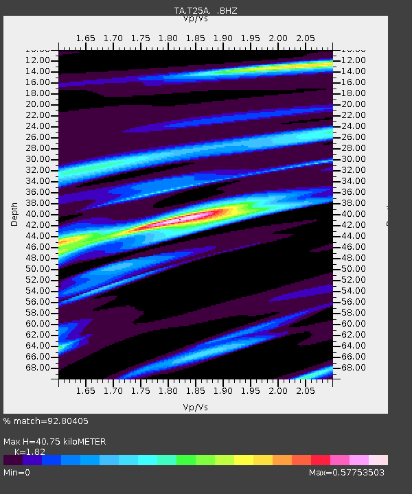
T25A Trinidad, CO, USA - Earthquake Result Viewer
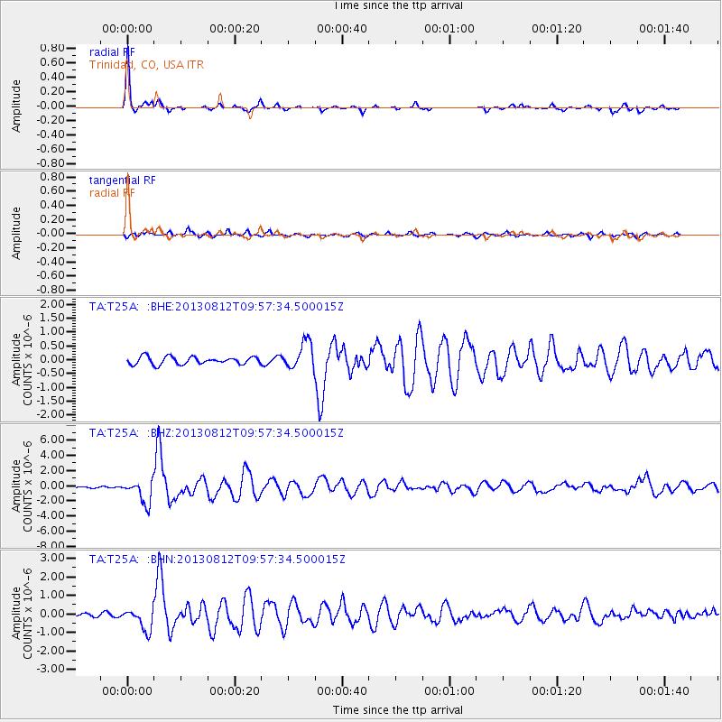
Earthquake location: Near Coast Of Northern Peru
Earthquake latitude/longitude: -5.4/-81.9
Earthquake time(UTC): 2013/08/12 (224) 09:49:32 GMT
Earthquake Depth: 10 km
Earthquake Magnitude: 6.2 MWW, 6.1 MWB, 6.2 MWW, 6.2 MWC, 6.3 MWC
Earthquake Catalog/Contributor: NEIC PDE/NEIC COMCAT
Network: TA USArray Transportable Network (new EarthScope stations)
Station: T25A Trinidad, CO, USA
Lat/Lon: 37.14 N/104.41 W
Elevation: 2017 m
Distance: 47.2 deg
Az: 335.401 deg
Baz: 148.76 deg
Ray Param: 0.07012477
Estimated Moho Depth: 40.75 km
Estimated Crust Vp/Vs: 1.82
Assumed Crust Vp: 6.316 km/s
Estimated Crust Vs: 3.47 km/s
Estimated Crust Poisson's Ratio: 0.28
Radial Match: 92.80405 %
Radial Bump: 238
Transverse Match: 81.49348 %
Transverse Bump: 400
SOD ConfigId: 626651
Insert Time: 2014-04-17 23:34:33.722 +0000
GWidth: 2.5
Max Bumps: 400
Tol: 0.001

Signal To Noise

ChannelStoNSTALTA
TA:T25A: :BHZ:20130812T09:57:34.500015Z12.00341.5398601E-61.2828532E-7
TA:T25A: :BHN:20130812T09:57:34.500015Z10.3340666.0489066E-75.853365E-8
TA:T25A: :BHE:20130812T09:57:34.500015Z3.64398384.936902E-71.354809E-7
Arrivals
Ps5.6 SECOND
PpPs17 SECOND
PsPs/PpSs23 SECOND