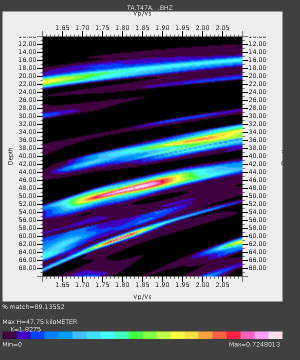
T47A Sharon Grove, KY, USA - Earthquake Result Viewer
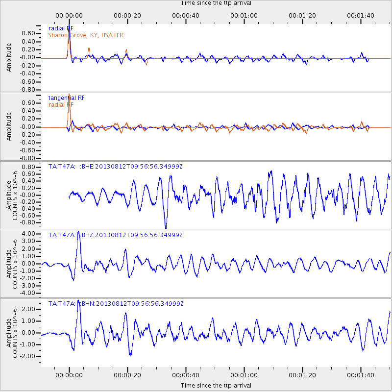
Earthquake location: Near Coast Of Northern Peru
Earthquake latitude/longitude: -5.4/-81.9
Earthquake time(UTC): 2013/08/12 (224) 09:49:32 GMT
Earthquake Depth: 10 km
Earthquake Magnitude: 6.2 MWW, 6.1 MWB, 6.2 MWW, 6.2 MWC, 6.3 MWC
Earthquake Catalog/Contributor: NEIC PDE/NEIC COMCAT
Network: TA USArray Transportable Network (new EarthScope stations)
Station: T47A Sharon Grove, KY, USA
Lat/Lon: 36.99 N/87.11 W
Elevation: 217 m
Distance: 42.4 deg
Az: 353.852 deg
Baz: 172.347 deg
Ray Param: 0.073173195
Estimated Moho Depth: 47.75 km
Estimated Crust Vp/Vs: 1.83
Assumed Crust Vp: 6.444 km/s
Estimated Crust Vs: 3.526 km/s
Estimated Crust Poisson's Ratio: 0.29
Radial Match: 89.13552 %
Radial Bump: 300
Transverse Match: 68.84204 %
Transverse Bump: 400
SOD ConfigId: 626651
Insert Time: 2014-04-17 23:34:37.230 +0000
GWidth: 2.5
Max Bumps: 400
Tol: 0.001

Signal To Noise

ChannelStoNSTALTA
TA:T47A: :BHZ:20130812T09:56:56.34999Z9.7481672.0002433E-62.0519174E-7
TA:T47A: :BHN:20130812T09:56:56.34999Z7.52549931.2917591E-61.7165095E-7
TA:T47A: :BHE:20130812T09:56:56.34999Z2.80728054.6214865E-71.6462504E-7
Arrivals
Ps6.5 SECOND
PpPs20 SECOND
PsPs/PpSs26 SECOND