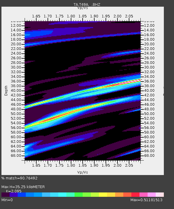
T49A Edmonton, KY, USA - Earthquake Result Viewer

Earthquake location: Near Coast Of Northern Peru
Earthquake latitude/longitude: -5.4/-81.9
Earthquake time(UTC): 2013/08/12 (224) 09:49:32 GMT
Earthquake Depth: 10 km
Earthquake Magnitude: 6.2 MWW, 6.1 MWB, 6.2 MWW, 6.2 MWC, 6.3 MWC
Earthquake Catalog/Contributor: NEIC PDE/NEIC COMCAT
Network: TA USArray Transportable Network (new EarthScope stations)
Station: T49A Edmonton, KY, USA
Lat/Lon: 37.10 N/85.53 W
Elevation: 313 m
Distance: 42.4 deg
Az: 355.724 deg
Baz: 174.672 deg
Ray Param: 0.07318829
Estimated Moho Depth: 35.25 km
Estimated Crust Vp/Vs: 2.10
Assumed Crust Vp: 6.476 km/s
Estimated Crust Vs: 3.091 km/s
Estimated Crust Poisson's Ratio: 0.35
Radial Match: 90.76492 %
Radial Bump: 298
Transverse Match: 62.20804 %
Transverse Bump: 400
SOD ConfigId: 626651
Insert Time: 2014-04-17 23:34:38.462 +0000
GWidth: 2.5
Max Bumps: 400
Tol: 0.001

Signal To Noise

ChannelStoNSTALTA
TA:T49A: :BHZ:20130812T09:56:56.150009Z19.4306342.077716E-61.06929924E-7
TA:T49A: :BHN:20130812T09:56:56.150009Z10.82984351.2558265E-61.1595981E-7
TA:T49A: :BHE:20130812T09:56:56.150009Z1.45595223.3972415E-72.333347E-7
Arrivals
Ps6.3 SECOND
PpPs16 SECOND
PsPs/PpSs22 SECOND