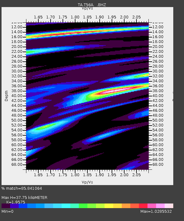
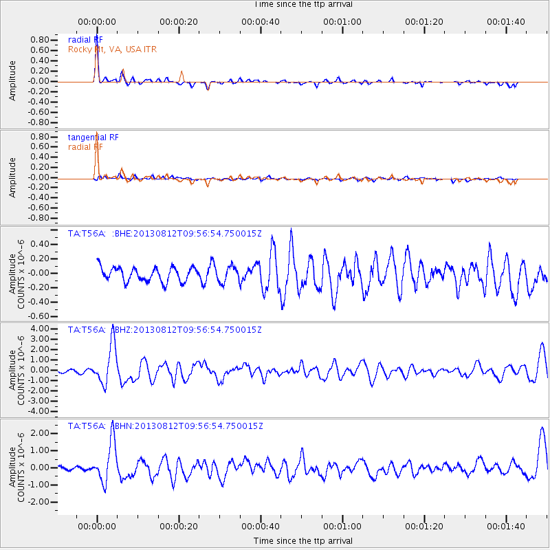
T56A Rocky Mt, VA, USA - Earthquake Result Viewer

Earthquake location: Near Coast Of Northern Peru
Earthquake latitude/longitude: -5.4/-81.9
Earthquake time(UTC): 2013/08/12 (224) 09:49:32 GMT
Earthquake Depth: 10 km
Earthquake Magnitude: 6.2 MWW, 6.1 MWB, 6.2 MWW, 6.2 MWC, 6.3 MWC
Earthquake Catalog/Contributor: NEIC PDE/NEIC COMCAT
Network: TA USArray Transportable Network (new EarthScope stations)
Station: T56A Rocky Mt, VA, USA
Lat/Lon: 37.03 N/80.03 W
Elevation: 387 m
Distance: 42.2 deg
Az: 2.257 deg
Baz: 182.808 deg
Ray Param: 0.07328771
Estimated Moho Depth: 37.75 km
Estimated Crust Vp/Vs: 1.96
Assumed Crust Vp: 6.159 km/s
Estimated Crust Vs: 3.146 km/s
Estimated Crust Poisson's Ratio: 0.32
Radial Match: 85.841064 %
Radial Bump: 354
Transverse Match: 52.81383 %
Transverse Bump: 400
SOD ConfigId: 626651
Insert Time: 2014-04-17 23:34:57.428 +0000
GWidth: 2.5
Max Bumps: 400
Tol: 0.001

Signal To Noise

ChannelStoNSTALTA
TA:T56A: :BHZ:20130812T09:56:54.750015Z13.3260961.973646E-61.4810384E-7
TA:T56A: :BHN:20130812T09:56:54.750015Z16.669471.2394272E-67.435313E-8
TA:T56A: :BHE:20130812T09:56:54.750015Z1.12618221.0857034E-79.6405664E-8
Arrivals
Ps6.2 SECOND
PpPs17 SECOND
PsPs/PpSs23 SECOND