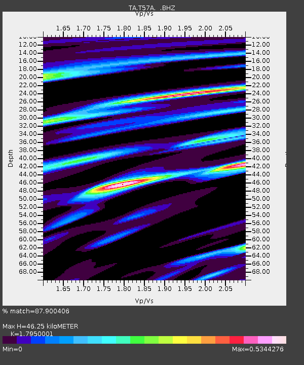
T57A Hurt, VA, USA - Earthquake Result Viewer
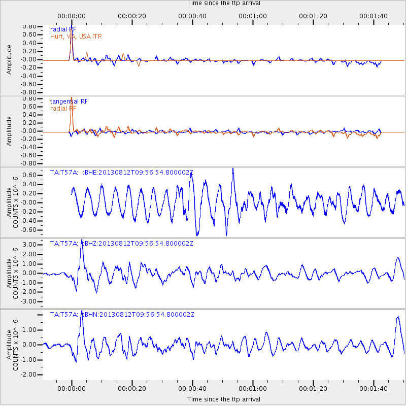
Earthquake location: Near Coast Of Northern Peru
Earthquake latitude/longitude: -5.4/-81.9
Earthquake time(UTC): 2013/08/12 (224) 09:49:32 GMT
Earthquake Depth: 10 km
Earthquake Magnitude: 6.2 MWW, 6.1 MWB, 6.2 MWW, 6.2 MWC, 6.3 MWC
Earthquake Catalog/Contributor: NEIC PDE/NEIC COMCAT
Network: TA USArray Transportable Network (new EarthScope stations)
Station: T57A Hurt, VA, USA
Lat/Lon: 37.00 N/79.25 W
Elevation: 230 m
Distance: 42.2 deg
Az: 3.183 deg
Baz: 183.96 deg
Ray Param: 0.07328407
Estimated Moho Depth: 46.25 km
Estimated Crust Vp/Vs: 1.80
Assumed Crust Vp: 6.419 km/s
Estimated Crust Vs: 3.576 km/s
Estimated Crust Poisson's Ratio: 0.27
Radial Match: 87.900406 %
Radial Bump: 316
Transverse Match: 33.336926 %
Transverse Bump: 400
SOD ConfigId: 626651
Insert Time: 2014-04-17 23:35:00.182 +0000
GWidth: 2.5
Max Bumps: 400
Tol: 0.001

Signal To Noise

ChannelStoNSTALTA
TA:T57A: :BHZ:20130812T09:56:54.800002Z6.58639861.4744948E-62.2386966E-7
TA:T57A: :BHN:20130812T09:56:54.800002Z8.9020829.802891E-71.1011907E-7
TA:T57A: :BHE:20130812T09:56:54.800002Z0.983062742.2371252E-72.2756687E-7
Arrivals
Ps6.1 SECOND
PpPs19 SECOND
PsPs/PpSs25 SECOND