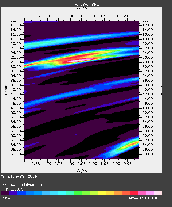
T58A Grand View Acres, VA, USA - Earthquake Result Viewer

Earthquake location: Near Coast Of Northern Peru
Earthquake latitude/longitude: -5.4/-81.9
Earthquake time(UTC): 2013/08/12 (224) 09:49:32 GMT
Earthquake Depth: 10 km
Earthquake Magnitude: 6.2 MWW, 6.1 MWB, 6.2 MWW, 6.2 MWC, 6.3 MWC
Earthquake Catalog/Contributor: NEIC PDE/NEIC COMCAT
Network: TA USArray Transportable Network (new EarthScope stations)
Station: T58A Grand View Acres, VA, USA
Lat/Lon: 36.95 N/78.53 W
Elevation: 167 m
Distance: 42.2 deg
Az: 4.045 deg
Baz: 185.029 deg
Ray Param: 0.07328835
Estimated Moho Depth: 27.0 km
Estimated Crust Vp/Vs: 1.84
Assumed Crust Vp: 6.419 km/s
Estimated Crust Vs: 3.493 km/s
Estimated Crust Poisson's Ratio: 0.29
Radial Match: 83.40959 %
Radial Bump: 252
Transverse Match: 50.648014 %
Transverse Bump: 400
SOD ConfigId: 626651
Insert Time: 2014-04-17 23:35:02.400 +0000
GWidth: 2.5
Max Bumps: 400
Tol: 0.001

Signal To Noise

ChannelStoNSTALTA
TA:T58A: :BHZ:20130812T09:56:54.72499Z19.7955531.6128929E-68.147754E-8
TA:T58A: :BHN:20130812T09:56:54.72499Z10.2985999.103979E-78.840017E-8
TA:T58A: :BHE:20130812T09:56:54.72499Z1.24684351.5050611E-71.2070971E-7
Arrivals
Ps3.8 SECOND
PpPs11 SECOND
PsPs/PpSs15 SECOND