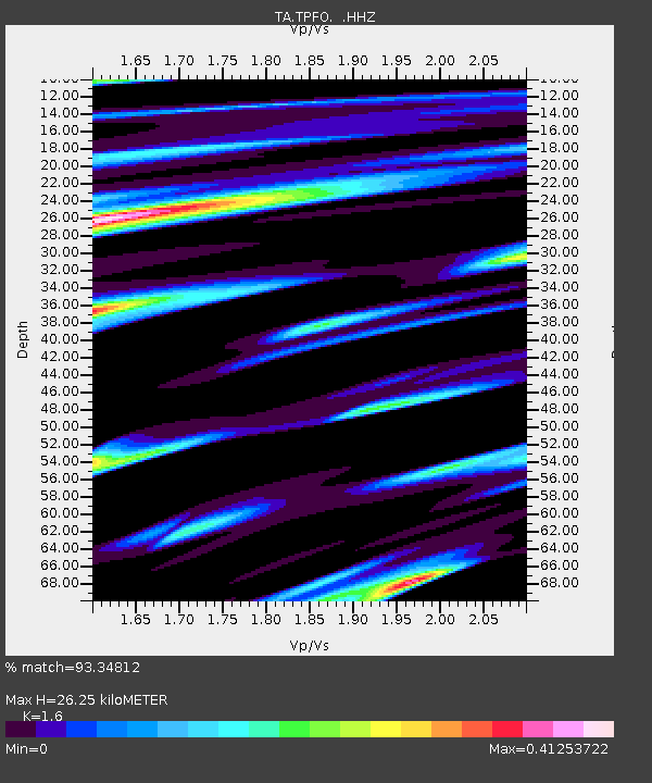
TPFO Pinon Flats, CA, USA - Earthquake Result Viewer
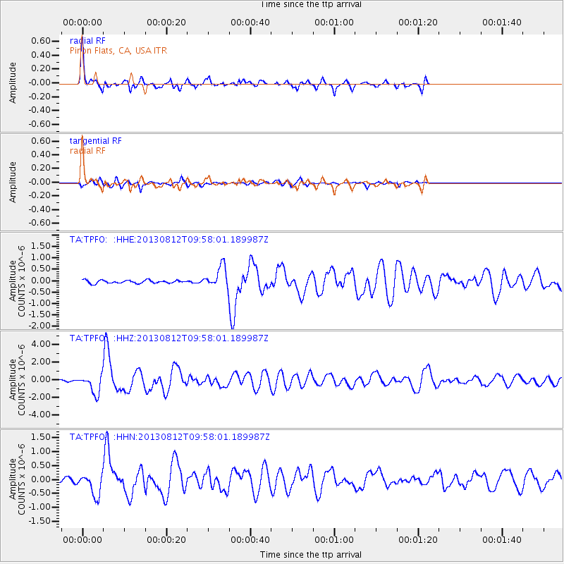
Earthquake location: Near Coast Of Northern Peru
Earthquake latitude/longitude: -5.4/-81.9
Earthquake time(UTC): 2013/08/12 (224) 09:49:32 GMT
Earthquake Depth: 10 km
Earthquake Magnitude: 6.2 MWW, 6.1 MWB, 6.2 MWW, 6.2 MWC, 6.3 MWC
Earthquake Catalog/Contributor: NEIC PDE/NEIC COMCAT
Network: TA USArray Transportable Network (new EarthScope stations)
Station: TPFO Pinon Flats, CA, USA
Lat/Lon: 33.61 N/116.45 W
Elevation: 1275 m
Distance: 50.7 deg
Az: 322.331 deg
Baz: 133.195 deg
Ray Param: 0.06786571
Estimated Moho Depth: 26.25 km
Estimated Crust Vp/Vs: 1.60
Assumed Crust Vp: 6.264 km/s
Estimated Crust Vs: 3.915 km/s
Estimated Crust Poisson's Ratio: 0.18
Radial Match: 93.34812 %
Radial Bump: 400
Transverse Match: 72.77441 %
Transverse Bump: 400
SOD ConfigId: 626651
Insert Time: 2014-04-17 23:35:16.539 +0000
GWidth: 2.5
Max Bumps: 400
Tol: 0.001

Signal To Noise

ChannelStoNSTALTA
TA:TPFO: :HHZ:20130812T09:58:01.189987Z10.5302091.0878388E-61.0330648E-7
TA:TPFO: :HHN:20130812T09:58:01.189987Z7.2289374.063831E-75.621616E-8
TA:TPFO: :HHE:20130812T09:58:01.189987Z7.4682224.858019E-76.50492E-8
Arrivals
Ps2.7 SECOND
PpPs10 SECOND
PsPs/PpSs13 SECOND