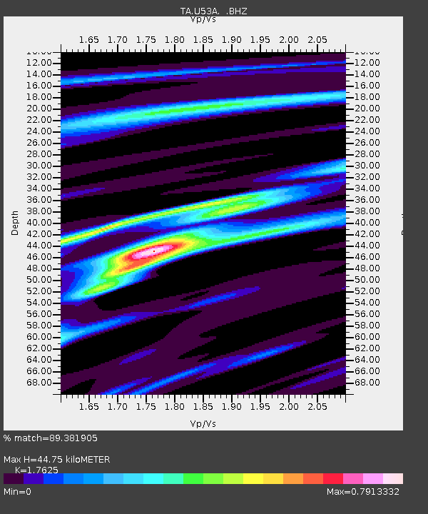
U53A Fall Branch, TN, USA - Earthquake Result Viewer

Earthquake location: Near Coast Of Northern Peru
Earthquake latitude/longitude: -5.4/-81.9
Earthquake time(UTC): 2013/08/12 (224) 09:49:32 GMT
Earthquake Depth: 10 km
Earthquake Magnitude: 6.2 MWW, 6.1 MWB, 6.2 MWW, 6.2 MWC, 6.3 MWC
Earthquake Catalog/Contributor: NEIC PDE/NEIC COMCAT
Network: TA USArray Transportable Network (new EarthScope stations)
Station: U53A Fall Branch, TN, USA
Lat/Lon: 36.36 N/82.58 W
Elevation: 559 m
Distance: 41.5 deg
Az: 359.209 deg
Baz: 179.025 deg
Ray Param: 0.07372435
Estimated Moho Depth: 44.75 km
Estimated Crust Vp/Vs: 1.76
Assumed Crust Vp: 6.476 km/s
Estimated Crust Vs: 3.674 km/s
Estimated Crust Poisson's Ratio: 0.26
Radial Match: 89.381905 %
Radial Bump: 344
Transverse Match: 55.975567 %
Transverse Bump: 400
SOD ConfigId: 626651
Insert Time: 2014-04-17 23:35:32.978 +0000
GWidth: 2.5
Max Bumps: 400
Tol: 0.001

Signal To Noise

ChannelStoNSTALTA
TA:U53A: :BHZ:20130812T09:56:49.050002Z11.2024941.9522947E-61.7427323E-7
TA:U53A: :BHN:20130812T09:56:49.050002Z7.4718471.1203992E-61.4994944E-7
TA:U53A: :BHE:20130812T09:56:49.050002Z0.608393551.3748982E-72.2598829E-7
Arrivals
Ps5.7 SECOND
PpPs18 SECOND
PsPs/PpSs23 SECOND