U58A Oxford, NC, USA - Earthquake Result Viewer
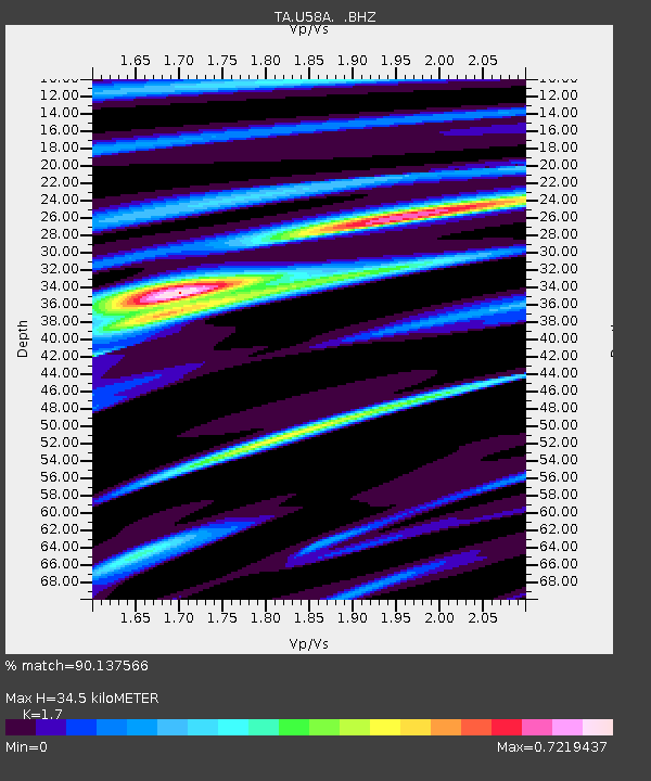
Earthquake location: Near Coast Of Northern Peru
Earthquake latitude/longitude: -5.4/-81.9
Earthquake time(UTC): 2013/08/12 (224) 09:49:32 GMT
Earthquake Depth: 10 km
Earthquake Magnitude: 6.2 MWW, 6.1 MWB, 6.2 MWW, 6.2 MWC, 6.3 MWC
Earthquake Catalog/Contributor: NEIC PDE/NEIC COMCAT
Network: TA USArray Transportable Network (new EarthScope stations)
Station: U58A Oxford, NC, USA
Lat/Lon: 36.39 N/78.55 W
Elevation: 169 m
Distance: 41.7 deg
Az: 4.098 deg
Baz: 185.059 deg
Ray Param: 0.07363215
Estimated Moho Depth: 34.5 km
Estimated Crust Vp/Vs: 1.70
Assumed Crust Vp: 6.419 km/s
Estimated Crust Vs: 3.776 km/s
Estimated Crust Poisson's Ratio: 0.24
Radial Match: 90.137566 %
Radial Bump: 283
Transverse Match: 68.184586 %
Transverse Bump: 400
SOD ConfigId: 626651
Insert Time: 2014-04-17 23:35:42.626 +0000
GWidth: 2.5
Max Bumps: 400
Tol: 0.001

Signal To Noise

ChannelStoNSTALTA
TA:U58A: :BHZ:20130812T09:56:50.250015Z15.8026631.5086108E-69.546561E-8
TA:U58A: :BHN:20130812T09:56:50.250015Z11.4921461.061147E-69.233672E-8
TA:U58A: :BHE:20130812T09:56:50.250015Z2.59437513.2102818E-71.2374007E-7
Arrivals
Ps4.0 SECOND
PpPs14 SECOND
PsPs/PpSs18 SECOND