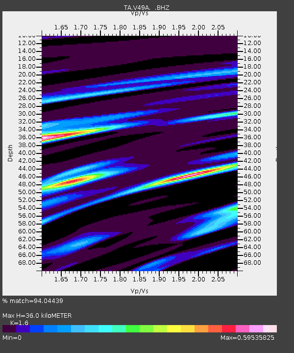
V49A McMinnville, TN, USA - Earthquake Result Viewer
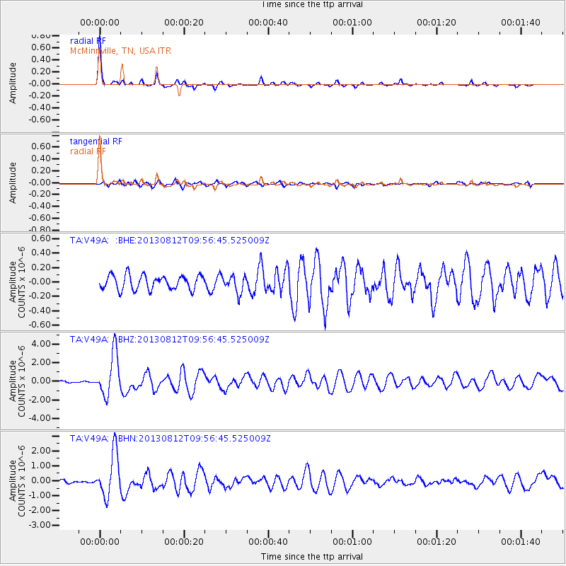
Earthquake location: Near Coast Of Northern Peru
Earthquake latitude/longitude: -5.4/-81.9
Earthquake time(UTC): 2013/08/12 (224) 09:49:32 GMT
Earthquake Depth: 10 km
Earthquake Magnitude: 6.2 MWW, 6.1 MWB, 6.2 MWW, 6.2 MWC, 6.3 MWC
Earthquake Catalog/Contributor: NEIC PDE/NEIC COMCAT
Network: TA USArray Transportable Network (new EarthScope stations)
Station: V49A McMinnville, TN, USA
Lat/Lon: 35.77 N/85.90 W
Elevation: 329 m
Distance: 41.1 deg
Az: 355.08 deg
Baz: 173.973 deg
Ray Param: 0.0739948
Estimated Moho Depth: 36.0 km
Estimated Crust Vp/Vs: 1.60
Assumed Crust Vp: 6.35 km/s
Estimated Crust Vs: 3.969 km/s
Estimated Crust Poisson's Ratio: 0.18
Radial Match: 94.04439 %
Radial Bump: 226
Transverse Match: 75.00159 %
Transverse Bump: 400
SOD ConfigId: 626651
Insert Time: 2014-04-17 23:35:56.610 +0000
GWidth: 2.5
Max Bumps: 400
Tol: 0.001

Signal To Noise

ChannelStoNSTALTA
TA:V49A: :BHZ:20130812T09:56:45.525009Z15.4239692.3223959E-61.5057056E-7
TA:V49A: :BHN:20130812T09:56:45.525009Z16.7950271.499539E-68.928471E-8
TA:V49A: :BHE:20130812T09:56:45.525009Z1.17368971.1575426E-79.862424E-8
Arrivals
Ps3.7 SECOND
PpPs14 SECOND
PsPs/PpSs17 SECOND