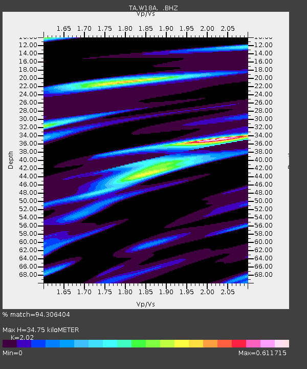
W18A Petrified Forest, AZ, USA - Earthquake Result Viewer

Earthquake location: Near Coast Of Northern Peru
Earthquake latitude/longitude: -5.4/-81.9
Earthquake time(UTC): 2013/08/12 (224) 09:49:32 GMT
Earthquake Depth: 10 km
Earthquake Magnitude: 6.2 MWW, 6.1 MWB, 6.2 MWW, 6.2 MWC, 6.3 MWC
Earthquake Catalog/Contributor: NEIC PDE/NEIC COMCAT
Network: TA USArray Transportable Network (new EarthScope stations)
Station: W18A Petrified Forest, AZ, USA
Lat/Lon: 35.12 N/109.74 W
Elevation: 1750 m
Distance: 48.1 deg
Az: 329.056 deg
Baz: 141.355 deg
Ray Param: 0.069602676
Estimated Moho Depth: 34.75 km
Estimated Crust Vp/Vs: 2.02
Assumed Crust Vp: 6.496 km/s
Estimated Crust Vs: 3.216 km/s
Estimated Crust Poisson's Ratio: 0.34
Radial Match: 94.306404 %
Radial Bump: 348
Transverse Match: 86.230606 %
Transverse Bump: 400
SOD ConfigId: 626651
Insert Time: 2014-04-17 23:36:29.870 +0000
GWidth: 2.5
Max Bumps: 400
Tol: 0.001

Signal To Noise

ChannelStoNSTALTA
TA:W18A: :BHZ:20130812T09:57:40.84999Z34.9704671.6659214E-64.763795E-8
TA:W18A: :BHN:20130812T09:57:40.84999Z5.1500677.131945E-71.3848256E-7
TA:W18A: :BHE:20130812T09:57:40.84999Z3.41891176.53127E-71.9103362E-7
Arrivals
Ps5.8 SECOND
PpPs15 SECOND
PsPs/PpSs21 SECOND