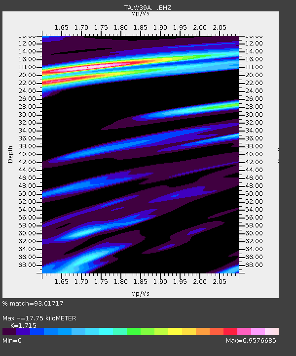
W39A Magazine, AR, USA - Earthquake Result Viewer

Earthquake location: Near Coast Of Northern Peru
Earthquake latitude/longitude: -5.4/-81.9
Earthquake time(UTC): 2013/08/12 (224) 09:49:32 GMT
Earthquake Depth: 10 km
Earthquake Magnitude: 6.2 MWW, 6.1 MWB, 6.2 MWW, 6.2 MWC, 6.3 MWC
Earthquake Catalog/Contributor: NEIC PDE/NEIC COMCAT
Network: TA USArray Transportable Network (new EarthScope stations)
Station: W39A Magazine, AR, USA
Lat/Lon: 35.20 N/93.78 W
Elevation: 162 m
Distance: 41.9 deg
Az: 345.402 deg
Baz: 162.159 deg
Ray Param: 0.07350441
Estimated Moho Depth: 17.75 km
Estimated Crust Vp/Vs: 1.72
Assumed Crust Vp: 6.498 km/s
Estimated Crust Vs: 3.789 km/s
Estimated Crust Poisson's Ratio: 0.24
Radial Match: 93.01717 %
Radial Bump: 304
Transverse Match: 83.25741 %
Transverse Bump: 380
SOD ConfigId: 626651
Insert Time: 2014-04-17 23:36:33.201 +0000
GWidth: 2.5
Max Bumps: 400
Tol: 0.001

Signal To Noise

ChannelStoNSTALTA
TA:W39A: :BHZ:20130812T09:56:51.874008Z4.4091132.4459891E-65.5475766E-7
TA:W39A: :BHN:20130812T09:56:51.874008Z2.8144098.5219017E-73.0279543E-7
TA:W39A: :BHE:20130812T09:56:51.874008Z1.27018123.6904814E-72.9054763E-7
Arrivals
Ps2.1 SECOND
PpPs6.9 SECOND
PsPs/PpSs9.0 SECOND