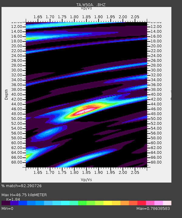
W50A Signal Mountain, TN, USA - Earthquake Result Viewer
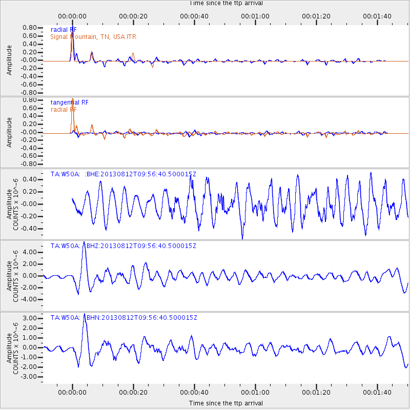
Earthquake location: Near Coast Of Northern Peru
Earthquake latitude/longitude: -5.4/-81.9
Earthquake time(UTC): 2013/08/12 (224) 09:49:32 GMT
Earthquake Depth: 10 km
Earthquake Magnitude: 6.2 MWW, 6.1 MWB, 6.2 MWW, 6.2 MWC, 6.3 MWC
Earthquake Catalog/Contributor: NEIC PDE/NEIC COMCAT
Network: TA USArray Transportable Network (new EarthScope stations)
Station: W50A Signal Mountain, TN, USA
Lat/Lon: 35.20 N/85.31 W
Elevation: 587 m
Distance: 40.5 deg
Az: 355.73 deg
Baz: 174.807 deg
Ray Param: 0.07436297
Estimated Moho Depth: 46.75 km
Estimated Crust Vp/Vs: 1.84
Assumed Crust Vp: 6.35 km/s
Estimated Crust Vs: 3.451 km/s
Estimated Crust Poisson's Ratio: 0.29
Radial Match: 92.290726 %
Radial Bump: 236
Transverse Match: 54.719196 %
Transverse Bump: 348
SOD ConfigId: 626651
Insert Time: 2014-04-17 23:36:37.441 +0000
GWidth: 2.5
Max Bumps: 400
Tol: 0.001

Signal To Noise

ChannelStoNSTALTA
TA:W50A: :BHZ:20130812T09:56:40.500015Z13.1709722.6579305E-62.0180215E-7
TA:W50A: :BHN:20130812T09:56:40.500015Z8.1359081.595451E-61.9609992E-7
TA:W50A: :BHE:20130812T09:56:40.500015Z0.850095751.5000516E-71.7645678E-7
Arrivals
Ps6.6 SECOND
PpPs20 SECOND
PsPs/PpSs26 SECOND