You are here: Home > Network List > TA - USArray Transportable Network (new EarthScope stations) Stations List
> Station X43A Marvell, AR, USA > Earthquake Result Viewer
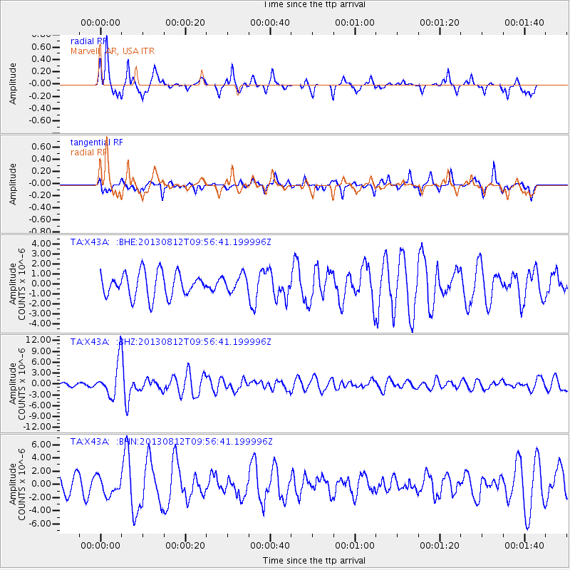
X43A Marvell, AR, USA - Earthquake Result Viewer
*The percent match for this event was below the threshold and hence no stack was calculated.
| Earthquake location: |
Near Coast Of Northern Peru |
| Earthquake latitude/longitude: |
-5.4/-81.9 |
| Earthquake time(UTC): |
2013/08/12 (224) 09:49:32 GMT |
| Earthquake Depth: |
10 km |
| Earthquake Magnitude: |
6.2 MWW, 6.1 MWB, 6.2 MWW, 6.2 MWC, 6.3 MWC |
| Earthquake Catalog/Contributor: |
NEIC PDE/NEIC COMCAT |
|
| Network: |
TA USArray Transportable Network (new EarthScope stations) |
| Station: |
X43A Marvell, AR, USA |
| Lat/Lon: |
34.52 N/90.88 W |
| Elevation: |
53 m |
|
| Distance: |
40.6 deg |
| Az: |
348.607 deg |
| Baz: |
166.221 deg |
| Ray Param: |
$rayparam |
*The percent match for this event was below the threshold and hence was not used in the summary stack. |
|
| Radial Match: |
72.15835 % |
| Radial Bump: |
300 |
| Transverse Match: |
53.964348 % |
| Transverse Bump: |
300 |
| SOD ConfigId: |
626651 |
| Insert Time: |
2014-04-17 23:37:11.887 +0000 |
| GWidth: |
2.5 |
| Max Bumps: |
400 |
| Tol: |
0.001 |
|
Signal To Noise
| Channel | StoN | STA | LTA |
| TA:X43A: :BHZ:20130812T09:56:41.199996Z | 12.970496 | 4.8693605E-6 | 3.7541818E-7 |
| TA:X43A: :BHN:20130812T09:56:41.199996Z | 1.2163368 | 1.3257868E-6 | 1.0899832E-6 |
| TA:X43A: :BHE:20130812T09:56:41.199996Z | 0.67197305 | 8.1447587E-7 | 1.2120662E-6 |
| Arrivals |
| Ps | |
| PpPs | |
| PsPs/PpSs | |


