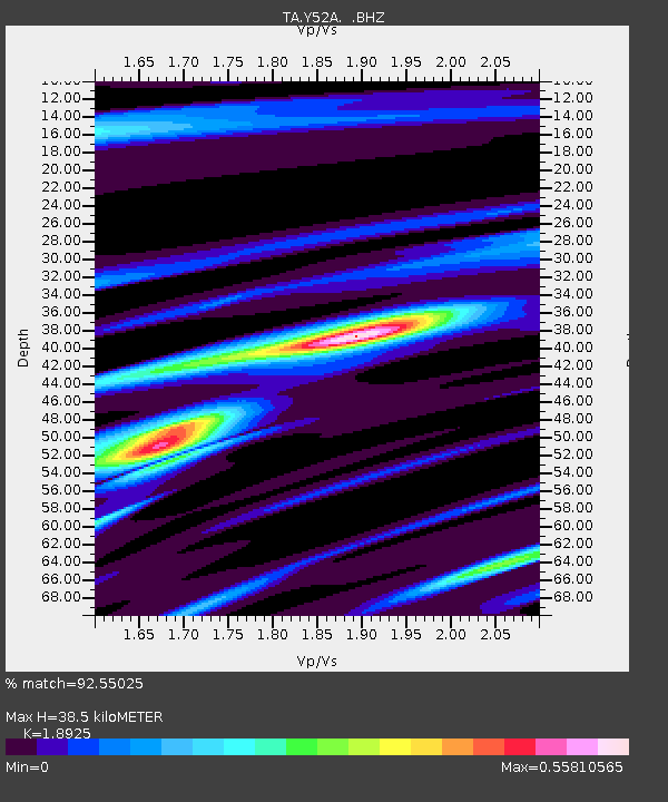
Y52A Lilburn, GA, USA - Earthquake Result Viewer
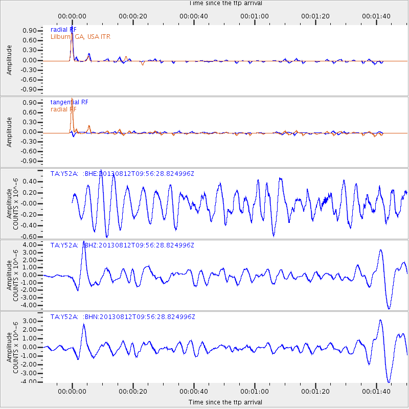
Earthquake location: Near Coast Of Northern Peru
Earthquake latitude/longitude: -5.4/-81.9
Earthquake time(UTC): 2013/08/12 (224) 09:49:32 GMT
Earthquake Depth: 10 km
Earthquake Magnitude: 6.2 MWW, 6.1 MWB, 6.2 MWW, 6.2 MWC, 6.3 MWC
Earthquake Catalog/Contributor: NEIC PDE/NEIC COMCAT
Network: TA USArray Transportable Network (new EarthScope stations)
Station: Y52A Lilburn, GA, USA
Lat/Lon: 33.86 N/84.06 W
Elevation: 286 m
Distance: 39.1 deg
Az: 357.182 deg
Baz: 176.627 deg
Ray Param: 0.07518021
Estimated Moho Depth: 38.5 km
Estimated Crust Vp/Vs: 1.89
Assumed Crust Vp: 6.719 km/s
Estimated Crust Vs: 3.551 km/s
Estimated Crust Poisson's Ratio: 0.31
Radial Match: 92.55025 %
Radial Bump: 155
Transverse Match: 45.03121 %
Transverse Bump: 386
SOD ConfigId: 626651
Insert Time: 2014-04-17 23:37:58.475 +0000
GWidth: 2.5
Max Bumps: 400
Tol: 0.001

Signal To Noise

ChannelStoNSTALTA
TA:Y52A: :BHZ:20130812T09:56:28.824996Z19.0486892.0249383E-61.063033E-7
TA:Y52A: :BHN:20130812T09:56:28.824996Z6.89051061.2002987E-61.741959E-7
TA:Y52A: :BHE:20130812T09:56:28.824996Z0.92707132.6751601E-72.8856036E-7
Arrivals
Ps5.5 SECOND
PpPs15 SECOND
PsPs/PpSs21 SECOND