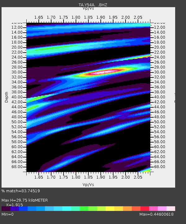
Y54A Tignall, GA, USA - Earthquake Result Viewer
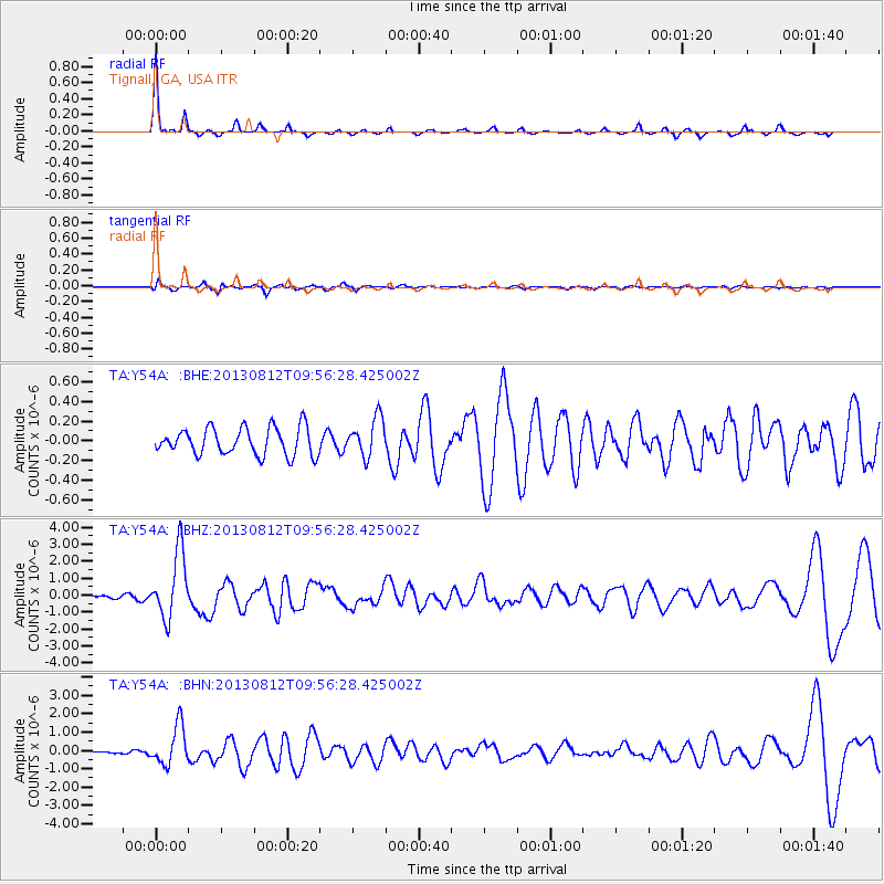
Earthquake location: Near Coast Of Northern Peru
Earthquake latitude/longitude: -5.4/-81.9
Earthquake time(UTC): 2013/08/12 (224) 09:49:32 GMT
Earthquake Depth: 10 km
Earthquake Magnitude: 6.2 MWW, 6.1 MWB, 6.2 MWW, 6.2 MWC, 6.3 MWC
Earthquake Catalog/Contributor: NEIC PDE/NEIC COMCAT
Network: TA USArray Transportable Network (new EarthScope stations)
Station: Y54A Tignall, GA, USA
Lat/Lon: 33.86 N/82.69 W
Elevation: 176 m
Distance: 39.1 deg
Az: 358.995 deg
Baz: 178.797 deg
Ray Param: 0.07520768
Estimated Moho Depth: 29.75 km
Estimated Crust Vp/Vs: 1.91
Assumed Crust Vp: 6.565 km/s
Estimated Crust Vs: 3.428 km/s
Estimated Crust Poisson's Ratio: 0.31
Radial Match: 83.74519 %
Radial Bump: 158
Transverse Match: 66.70103 %
Transverse Bump: 378
SOD ConfigId: 626651
Insert Time: 2014-04-17 23:38:02.328 +0000
GWidth: 2.5
Max Bumps: 400
Tol: 0.001

Signal To Noise

ChannelStoNSTALTA
TA:Y54A: :BHZ:20130812T09:56:28.425002Z16.8104021.9503864E-61.1602258E-7
TA:Y54A: :BHN:20130812T09:56:28.425002Z10.0767971.0736026E-61.0654205E-7
TA:Y54A: :BHE:20130812T09:56:28.425002Z1.40536311.9505978E-71.3879672E-7
Arrivals
Ps4.4 SECOND
PpPs12 SECOND
PsPs/PpSs17 SECOND