Z50A Ashland, AL, USA - Earthquake Result Viewer
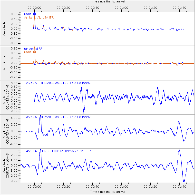
Earthquake location: Near Coast Of Northern Peru
Earthquake latitude/longitude: -5.4/-81.9
Earthquake time(UTC): 2013/08/12 (224) 09:49:32 GMT
Earthquake Depth: 10 km
Earthquake Magnitude: 6.2 MWW, 6.1 MWB, 6.2 MWW, 6.2 MWC, 6.3 MWC
Earthquake Catalog/Contributor: NEIC PDE/NEIC COMCAT
Network: TA USArray Transportable Network (new EarthScope stations)
Station: Z50A Ashland, AL, USA
Lat/Lon: 33.25 N/85.92 W
Elevation: 370 m
Distance: 38.6 deg
Az: 354.633 deg
Baz: 173.619 deg
Ray Param: 0.0754541
Estimated Moho Depth: 50.25 km
Estimated Crust Vp/Vs: 1.75
Assumed Crust Vp: 6.719 km/s
Estimated Crust Vs: 3.834 km/s
Estimated Crust Poisson's Ratio: 0.26
Radial Match: 93.65352 %
Radial Bump: 220
Transverse Match: 59.73436 %
Transverse Bump: 400
SOD ConfigId: 626651
Insert Time: 2014-04-17 23:38:17.891 +0000
GWidth: 2.5
Max Bumps: 400
Tol: 0.001

Signal To Noise

ChannelStoNSTALTA
TA:Z50A: :BHZ:20130812T09:56:24.84999Z21.0196272.2028669E-61.0480047E-7
TA:Z50A: :BHN:20130812T09:56:24.84999Z10.1316661.4501757E-61.4313298E-7
TA:Z50A: :BHE:20130812T09:56:24.84999Z2.82385334.0852856E-71.4467061E-7
Arrivals
Ps6.1 SECOND
PpPs19 SECOND
PsPs/PpSs25 SECOND