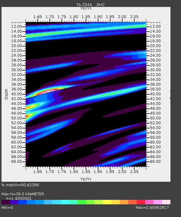
Z54A Sparta, GA, USA - Earthquake Result Viewer
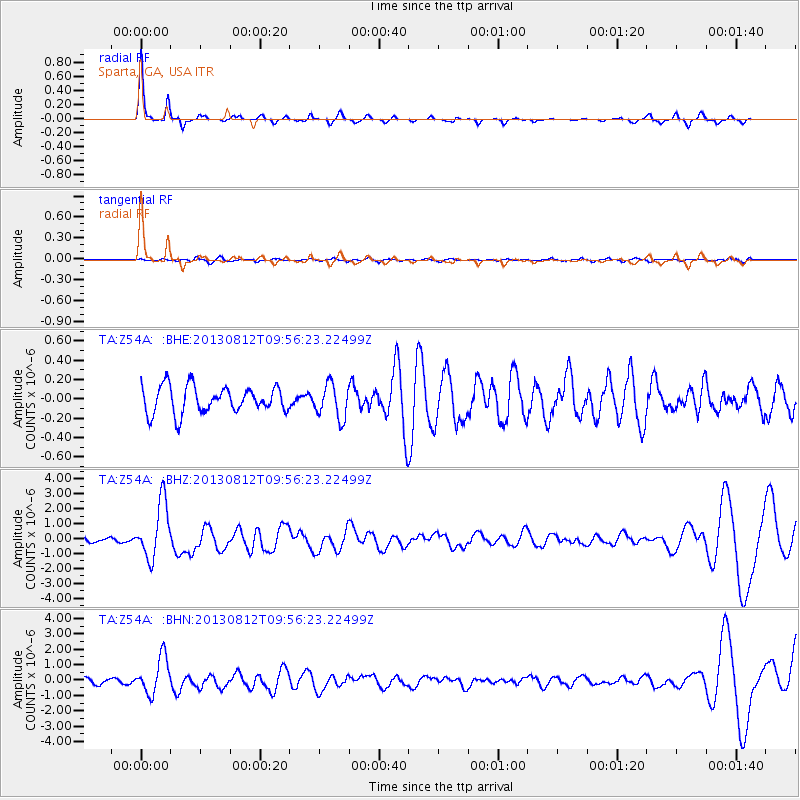
Earthquake location: Near Coast Of Northern Peru
Earthquake latitude/longitude: -5.4/-81.9
Earthquake time(UTC): 2013/08/12 (224) 09:49:32 GMT
Earthquake Depth: 10 km
Earthquake Magnitude: 6.2 MWW, 6.1 MWB, 6.2 MWW, 6.2 MWC, 6.3 MWC
Earthquake Catalog/Contributor: NEIC PDE/NEIC COMCAT
Network: TA USArray Transportable Network (new EarthScope stations)
Station: Z54A Sparta, GA, USA
Lat/Lon: 33.24 N/82.84 W
Elevation: 134 m
Distance: 38.4 deg
Az: 358.766 deg
Baz: 178.534 deg
Ray Param: 0.07556643
Estimated Moho Depth: 39.0 km
Estimated Crust Vp/Vs: 1.69
Assumed Crust Vp: 6.565 km/s
Estimated Crust Vs: 3.896 km/s
Estimated Crust Poisson's Ratio: 0.23
Radial Match: 90.62298 %
Radial Bump: 200
Transverse Match: 39.030735 %
Transverse Bump: 400
SOD ConfigId: 626651
Insert Time: 2014-04-17 23:38:26.766 +0000
GWidth: 2.5
Max Bumps: 400
Tol: 0.001

Signal To Noise

ChannelStoNSTALTA
TA:Z54A: :BHZ:20130812T09:56:23.22499Z7.7184381.8776832E-62.432724E-7
TA:Z54A: :BHN:20130812T09:56:23.22499Z6.3024151.1757668E-61.8655814E-7
TA:Z54A: :BHE:20130812T09:56:23.22499Z1.29147931.7683539E-71.3692467E-7
Arrivals
Ps4.4 SECOND
PpPs15 SECOND
PsPs/PpSs19 SECOND