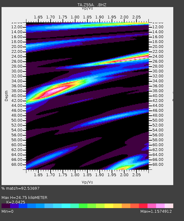
Z55A Blythe, GA, USA - Earthquake Result Viewer
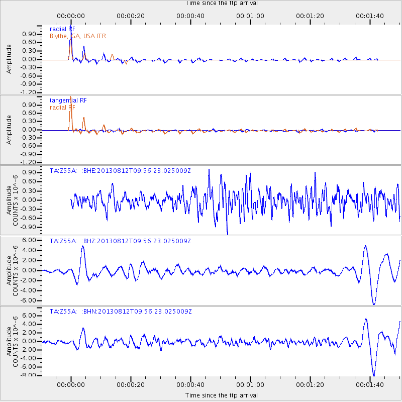
Earthquake location: Near Coast Of Northern Peru
Earthquake latitude/longitude: -5.4/-81.9
Earthquake time(UTC): 2013/08/12 (224) 09:49:32 GMT
Earthquake Depth: 10 km
Earthquake Magnitude: 6.2 MWW, 6.1 MWB, 6.2 MWW, 6.2 MWC, 6.3 MWC
Earthquake Catalog/Contributor: NEIC PDE/NEIC COMCAT
Network: TA USArray Transportable Network (new EarthScope stations)
Station: Z55A Blythe, GA, USA
Lat/Lon: 33.22 N/82.14 W
Elevation: 100 m
Distance: 38.4 deg
Az: 359.718 deg
Baz: 179.665 deg
Ray Param: 0.0755805
Estimated Moho Depth: 24.75 km
Estimated Crust Vp/Vs: 2.04
Assumed Crust Vp: 6.565 km/s
Estimated Crust Vs: 3.214 km/s
Estimated Crust Poisson's Ratio: 0.34
Radial Match: 92.53697 %
Radial Bump: 170
Transverse Match: 45.43982 %
Transverse Bump: 400
SOD ConfigId: 626651
Insert Time: 2014-04-17 23:38:28.663 +0000
GWidth: 2.5
Max Bumps: 400
Tol: 0.001

Signal To Noise

ChannelStoNSTALTA
TA:Z55A: :BHZ:20130812T09:56:23.025009Z16.9975472.3797315E-61.4000442E-7
TA:Z55A: :BHN:20130812T09:56:23.025009Z6.98047641.525312E-62.1851116E-7
TA:Z55A: :BHE:20130812T09:56:23.025009Z0.80791331.6110556E-71.9940947E-7
Arrivals
Ps4.2 SECOND
PpPs11 SECOND
PsPs/PpSs15 SECOND