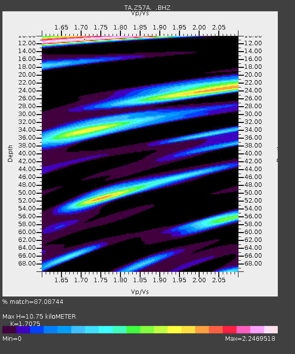
Z57A Bowman, SC, USA - Earthquake Result Viewer

Earthquake location: Near Coast Of Northern Peru
Earthquake latitude/longitude: -5.4/-81.9
Earthquake time(UTC): 2013/08/12 (224) 09:49:32 GMT
Earthquake Depth: 10 km
Earthquake Magnitude: 6.2 MWW, 6.1 MWB, 6.2 MWW, 6.2 MWC, 6.3 MWC
Earthquake Catalog/Contributor: NEIC PDE/NEIC COMCAT
Network: TA USArray Transportable Network (new EarthScope stations)
Station: Z57A Bowman, SC, USA
Lat/Lon: 33.30 N/80.70 W
Elevation: 81 m
Distance: 38.5 deg
Az: 1.645 deg
Baz: 181.956 deg
Ray Param: 0.075526975
Estimated Moho Depth: 10.75 km
Estimated Crust Vp/Vs: 1.71
Assumed Crust Vp: 6.565 km/s
Estimated Crust Vs: 3.845 km/s
Estimated Crust Poisson's Ratio: 0.24
Radial Match: 87.08744 %
Radial Bump: 400
Transverse Match: 59.118744 %
Transverse Bump: 400
SOD ConfigId: 626651
Insert Time: 2014-04-17 23:38:33.588 +0000
GWidth: 2.5
Max Bumps: 400
Tol: 0.001

Signal To Noise

ChannelStoNSTALTA
TA:Z57A: :BHZ:20130812T09:56:23.800002Z11.8006721.8438552E-61.5625002E-7
TA:Z57A: :BHN:20130812T09:56:23.800002Z5.2052361.920282E-63.6891356E-7
TA:Z57A: :BHE:20130812T09:56:23.800002Z0.808122933.5683584E-74.4156135E-7
Arrivals
Ps1.3 SECOND
PpPs4.1 SECOND
PsPs/PpSs5.4 SECOND