Z59A Georgetown, SC, USA - Earthquake Result Viewer
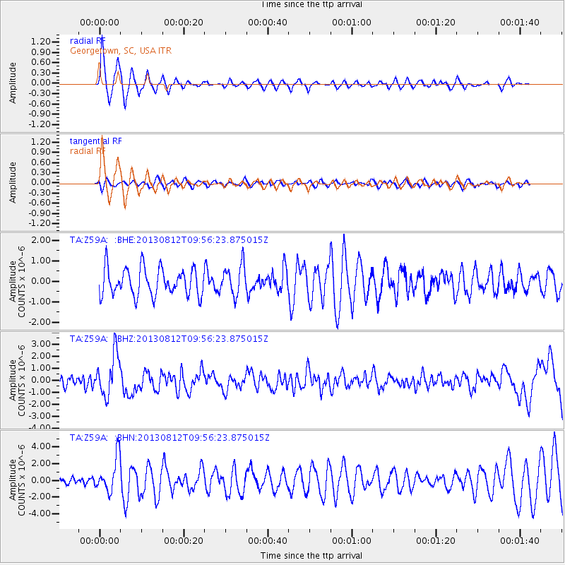
Earthquake location: Near Coast Of Northern Peru
Earthquake latitude/longitude: -5.4/-81.9
Earthquake time(UTC): 2013/08/12 (224) 09:49:32 GMT
Earthquake Depth: 10 km
Earthquake Magnitude: 6.2 MWW, 6.1 MWB, 6.2 MWW, 6.2 MWC, 6.3 MWC
Earthquake Catalog/Contributor: NEIC PDE/NEIC COMCAT
Network: TA USArray Transportable Network (new EarthScope stations)
Station: Z59A Georgetown, SC, USA
Lat/Lon: 33.24 N/79.28 W
Elevation: 8.0 m
Distance: 38.5 deg
Az: 3.566 deg
Baz: 184.238 deg
Ray Param: 0.07552167
Estimated Moho Depth: 12.75 km
Estimated Crust Vp/Vs: 1.60
Assumed Crust Vp: 6.24 km/s
Estimated Crust Vs: 3.9 km/s
Estimated Crust Poisson's Ratio: 0.18
Radial Match: 90.79732 %
Radial Bump: 400
Transverse Match: 48.91868 %
Transverse Bump: 400
SOD ConfigId: 626651
Insert Time: 2014-04-17 23:38:39.309 +0000
GWidth: 2.5
Max Bumps: 400
Tol: 0.001

Signal To Noise

ChannelStoNSTALTA
TA:Z59A: :BHZ:20130812T09:56:23.875015Z5.5249191.8104329E-63.2768497E-7
TA:Z59A: :BHN:20130812T09:56:23.875015Z4.68059062.150924E-64.5954116E-7
TA:Z59A: :BHE:20130812T09:56:23.875015Z1.12710267.437853E-76.599091E-7
Arrivals
Ps1.3 SECOND
PpPs4.9 SECOND
PsPs/PpSs6.2 SECOND