You are here: Home > Network List > US - United States National Seismic Network Stations List
> Station EGAK Eagle, Central Alaska, Alaska, USA > Earthquake Result Viewer
EGAK Eagle, Central Alaska, Alaska, USA - Earthquake Result Viewer

| Earthquake location: |
Near Coast Of Northern Peru |
| Earthquake latitude/longitude: |
-5.4/-81.9 |
| Earthquake time(UTC): |
2013/08/12 (224) 09:49:32 GMT |
| Earthquake Depth: |
10 km |
| Earthquake Magnitude: |
6.2 MWW, 6.1 MWB, 6.2 MWW, 6.2 MWC, 6.3 MWC |
| Earthquake Catalog/Contributor: |
NEIC PDE/NEIC COMCAT |
|
| Network: |
US United States National Seismic Network |
| Station: |
EGAK Eagle, Central Alaska, Alaska, USA |
| Lat/Lon: |
64.78 N/141.16 W |
| Elevation: |
297 m |
|
| Distance: |
82.3 deg |
| Az: |
338.191 deg |
| Baz: |
120.317 deg |
| Ray Param: |
0.046976805 |
| Estimated Moho Depth: |
34.25 km |
| Estimated Crust Vp/Vs: |
2.10 |
| Assumed Crust Vp: |
6.566 km/s |
| Estimated Crust Vs: |
3.13 km/s |
| Estimated Crust Poisson's Ratio: |
0.35 |
|
| Radial Match: |
92.05294 % |
| Radial Bump: |
400 |
| Transverse Match: |
86.30769 % |
| Transverse Bump: |
400 |
| SOD ConfigId: |
626651 |
| Insert Time: |
2014-04-17 23:39:29.865 +0000 |
| GWidth: |
2.5 |
| Max Bumps: |
400 |
| Tol: |
0.001 |
|
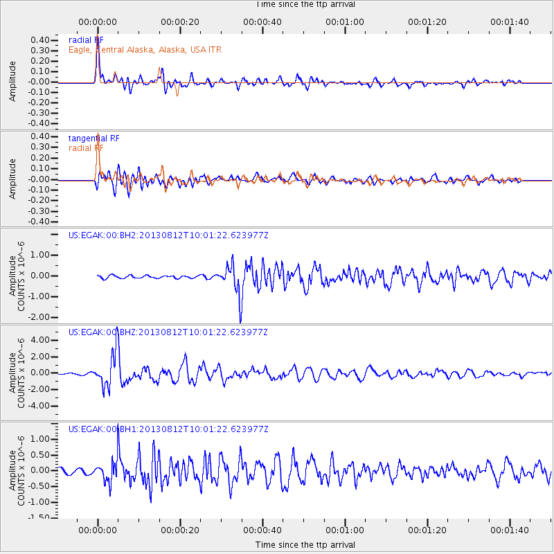
Signal To Noise
| Channel | StoN | STA | LTA |
| US:EGAK:00:BHZ:20130812T10:01:22.623977Z | 22.548498 | 2.1722942E-6 | 9.633875E-8 |
| US:EGAK:00:BH1:20130812T10:01:22.623977Z | 2.7595901 | 3.3953978E-7 | 1.2303992E-7 |
| US:EGAK:00:BH2:20130812T10:01:22.623977Z | 11.280989 | 7.2826407E-7 | 6.455676E-8 |
| Arrivals |
| Ps | 5.9 SECOND |
| PpPs | 16 SECOND |
| PsPs/PpSs | 22 SECOND |


