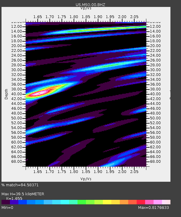
MSO Missoula, Montana, USA - Earthquake Result Viewer

Earthquake location: Near Coast Of Northern Peru
Earthquake latitude/longitude: -5.4/-81.9
Earthquake time(UTC): 2013/08/12 (224) 09:49:32 GMT
Earthquake Depth: 10 km
Earthquake Magnitude: 6.2 MWW, 6.1 MWB, 6.2 MWW, 6.2 MWC, 6.3 MWC
Earthquake Catalog/Contributor: NEIC PDE/NEIC COMCAT
Network: US United States National Seismic Network
Station: MSO Missoula, Montana, USA
Lat/Lon: 46.83 N/113.94 W
Elevation: 1264 m
Distance: 59.2 deg
Az: 334.934 deg
Baz: 142.096 deg
Ray Param: 0.06233229
Estimated Moho Depth: 39.5 km
Estimated Crust Vp/Vs: 1.65
Assumed Crust Vp: 6.353 km/s
Estimated Crust Vs: 3.839 km/s
Estimated Crust Poisson's Ratio: 0.21
Radial Match: 94.58371 %
Radial Bump: 384
Transverse Match: 83.06333 %
Transverse Bump: 400
SOD ConfigId: 626651
Insert Time: 2014-04-17 23:40:25.276 +0000
GWidth: 2.5
Max Bumps: 400
Tol: 0.001

Signal To Noise

ChannelStoNSTALTA
US:MSO:00:BHZ:20130812T09:59:02.550002Z10.3849241.5091687E-61.4532304E-7
US:MSO:00:BH1:20130812T09:59:02.550002Z4.32819136.169429E-71.4254057E-7
US:MSO:00:BH2:20130812T09:59:02.550002Z7.0537794.531758E-76.424582E-8
Arrivals
Ps4.3 SECOND
PpPs16 SECOND
PsPs/PpSs20 SECOND