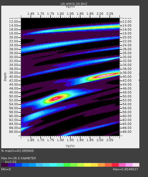
WMOK Wichita Mountains, Oklahoma, USA - Earthquake Result Viewer

Earthquake location: Near Coast Of Northern Peru
Earthquake latitude/longitude: -5.4/-81.9
Earthquake time(UTC): 2013/08/12 (224) 09:49:32 GMT
Earthquake Depth: 10 km
Earthquake Magnitude: 6.2 MWW, 6.1 MWB, 6.2 MWW, 6.2 MWC, 6.3 MWC
Earthquake Catalog/Contributor: NEIC PDE/NEIC COMCAT
Network: US United States National Seismic Network
Station: WMOK Wichita Mountains, Oklahoma, USA
Lat/Lon: 34.74 N/98.78 W
Elevation: 486 m
Distance: 43.0 deg
Az: 339.493 deg
Baz: 154.942 deg
Ray Param: 0.07285285
Estimated Moho Depth: 39.0 km
Estimated Crust Vp/Vs: 2.03
Assumed Crust Vp: 6.315 km/s
Estimated Crust Vs: 3.111 km/s
Estimated Crust Poisson's Ratio: 0.34
Radial Match: 92.095985 %
Radial Bump: 355
Transverse Match: 64.56734 %
Transverse Bump: 400
SOD ConfigId: 626651
Insert Time: 2014-04-17 23:41:01.294 +0000
GWidth: 2.5
Max Bumps: 400
Tol: 0.001

Signal To Noise

ChannelStoNSTALTA
US:WMOK:00:BHZ:20130812T09:57:00.625015Z24.9089532.671001E-61.0723057E-7
US:WMOK:00:BH1:20130812T09:57:00.625015Z10.6219121.4131818E-61.3304401E-7
US:WMOK:00:BH2:20130812T09:57:00.625015Z3.4833544.795359E-71.3766498E-7
Arrivals
Ps6.7 SECOND
PpPs18 SECOND
PsPs/PpSs24 SECOND