You are here: Home > Network List > UU - University of Utah Regional Network Stations List
> Station BRPU Butcher Ranch, Price, UT, USA old TA-P17A > Earthquake Result Viewer
BRPU Butcher Ranch, Price, UT, USA old TA-P17A - Earthquake Result Viewer
| Earthquake location: |
Near Coast Of Northern Peru |
| Earthquake latitude/longitude: |
-5.4/-81.9 |
| Earthquake time(UTC): |
2013/08/12 (224) 09:49:32 GMT |
| Earthquake Depth: |
10 km |
| Earthquake Magnitude: |
6.2 MWW, 6.1 MWB, 6.2 MWW, 6.2 MWC, 6.3 MWC |
| Earthquake Catalog/Contributor: |
NEIC PDE/NEIC COMCAT |
|
| Network: |
UU University of Utah Regional Network |
| Station: |
BRPU Butcher Ranch, Price, UT, USA old TA-P17A |
| Lat/Lon: |
39.47 N/110.74 W |
| Elevation: |
1687 m |
|
| Distance: |
52.0 deg |
| Az: |
331.733 deg |
| Baz: |
142.469 deg |
| Ray Param: |
0.06706279 |
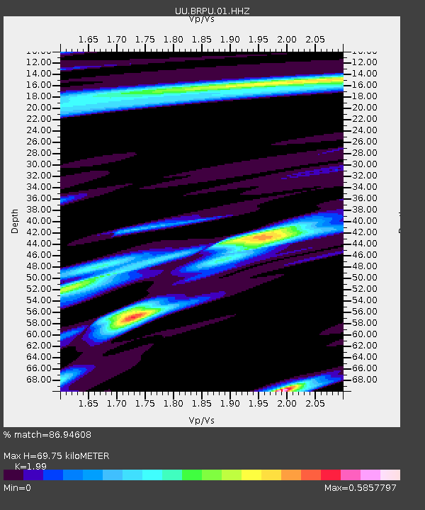
| Estimated Moho Depth: |
69.75 km |
| Estimated Crust Vp/Vs: |
1.99 |
| Assumed Crust Vp: |
6.207 km/s |
| Estimated Crust Vs: |
3.119 km/s |
| Estimated Crust Poisson's Ratio: |
0.33 |
|
| Radial Match: |
86.94608 % |
| Radial Bump: |
307 |
| Transverse Match: |
76.36617 % |
| Transverse Bump: |
400 |
| SOD ConfigId: |
626651 |
| Insert Time: |
2014-04-17 23:41:12.566 +0000 |
| GWidth: |
2.5 |
| Max Bumps: |
400 |
| Tol: |
0.001 |
|

Signal To Noise
| Channel | StoN | STA | LTA |
| UU:BRPU:01:HHZ:20130812T09:58:10.52803Z | 13.682069 | 5.1087564E-8 | 3.7339065E-9 |
| UU:BRPU:01:HHN:20130812T09:58:10.52803Z | 5.897528 | 1.9594747E-8 | 3.3225358E-9 |
| UU:BRPU:01:HHE:20130812T09:58:10.52803Z | 5.9311357 | 1.3099993E-8 | 2.2086821E-9 |
| Arrivals |
| Ps | 12 SECOND |
| PpPs | 32 SECOND |
| PsPs/PpSs | 44 SECOND |


