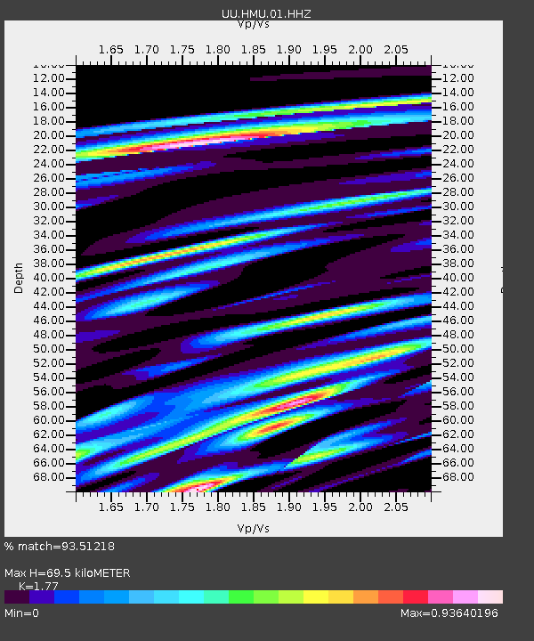
HMU Henry Mountain, UT, USA - Earthquake Result Viewer

Earthquake location: Near Coast Of Northern Peru
Earthquake latitude/longitude: -5.4/-81.9
Earthquake time(UTC): 2013/08/12 (224) 09:49:32 GMT
Earthquake Depth: 10 km
Earthquake Magnitude: 6.2 MWW, 6.1 MWB, 6.2 MWW, 6.2 MWC, 6.3 MWC
Earthquake Catalog/Contributor: NEIC PDE/NEIC COMCAT
Network: UU University of Utah Regional Network
Station: HMU Henry Mountain, UT, USA
Lat/Lon: 37.94 N/110.74 W
Elevation: 2430 m
Distance: 50.8 deg
Az: 330.526 deg
Baz: 141.715 deg
Ray Param: 0.06783838
Estimated Moho Depth: 69.5 km
Estimated Crust Vp/Vs: 1.77
Assumed Crust Vp: 6.247 km/s
Estimated Crust Vs: 3.529 km/s
Estimated Crust Poisson's Ratio: 0.27
Radial Match: 93.51218 %
Radial Bump: 400
Transverse Match: 79.67877 %
Transverse Bump: 400
SOD ConfigId: 626651
Insert Time: 2014-04-17 23:41:22.037 +0000
GWidth: 2.5
Max Bumps: 400
Tol: 0.001

Signal To Noise

ChannelStoNSTALTA
UU:HMU:01:HHZ:20130812T09:58:01.491012Z10.9899754.6580517E-84.238455E-9
UU:HMU:01:HHN:20130812T09:58:01.491012Z8.992952.4138243E-82.6841294E-9
UU:HMU:01:HHE:20130812T09:58:01.491012Z7.33562041.7397095E-82.3715916E-9
Arrivals
Ps9.0 SECOND
PpPs29 SECOND
PsPs/PpSs38 SECOND