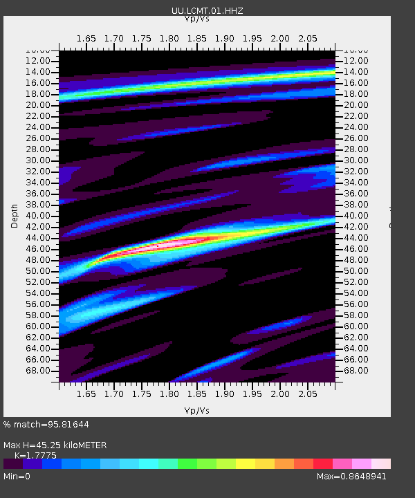
LCMT Little Creek Mountain, UT, USA - Earthquake Result Viewer
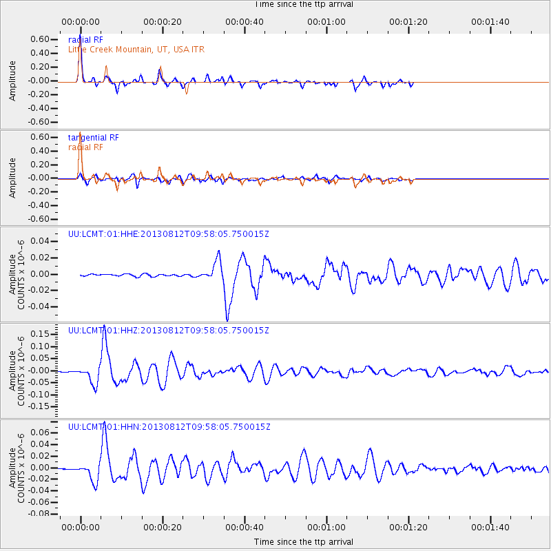
Earthquake location: Near Coast Of Northern Peru
Earthquake latitude/longitude: -5.4/-81.9
Earthquake time(UTC): 2013/08/12 (224) 09:49:32 GMT
Earthquake Depth: 10 km
Earthquake Magnitude: 6.2 MWW, 6.1 MWB, 6.2 MWW, 6.2 MWC, 6.3 MWC
Earthquake Catalog/Contributor: NEIC PDE/NEIC COMCAT
Network: UU University of Utah Regional Network
Station: LCMT Little Creek Mountain, UT, USA
Lat/Lon: 37.01 N/113.24 W
Elevation: 1411 m
Distance: 51.3 deg
Az: 327.799 deg
Baz: 138.484 deg
Ray Param: 0.06748235
Estimated Moho Depth: 45.25 km
Estimated Crust Vp/Vs: 1.78
Assumed Crust Vp: 6.194 km/s
Estimated Crust Vs: 3.485 km/s
Estimated Crust Poisson's Ratio: 0.27
Radial Match: 95.81644 %
Radial Bump: 274
Transverse Match: 84.76342 %
Transverse Bump: 400
SOD ConfigId: 626651
Insert Time: 2014-04-17 23:41:31.061 +0000
GWidth: 2.5
Max Bumps: 400
Tol: 0.001

Signal To Noise

ChannelStoNSTALTA
UU:LCMT:01:HHZ:20130812T09:58:05.750015Z21.220553.7381874E-81.7615882E-9
UU:LCMT:01:HHN:20130812T09:58:05.750015Z15.3686021.6511239E-81.0743487E-9
UU:LCMT:01:HHE:20130812T09:58:05.750015Z9.4734761.2554605E-81.3252374E-9
Arrivals
Ps6.0 SECOND
PpPs19 SECOND
PsPs/PpSs25 SECOND