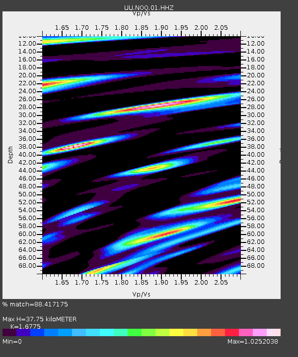
NOQ North Oquirrh Mountains, UT, USA - Earthquake Result Viewer

Earthquake location: Near Coast Of Northern Peru
Earthquake latitude/longitude: -5.4/-81.9
Earthquake time(UTC): 2013/08/12 (224) 09:49:32 GMT
Earthquake Depth: 10 km
Earthquake Magnitude: 6.2 MWW, 6.1 MWB, 6.2 MWW, 6.2 MWC, 6.3 MWC
Earthquake Catalog/Contributor: NEIC PDE/NEIC COMCAT
Network: UU University of Utah Regional Network
Station: NOQ North Oquirrh Mountains, UT, USA
Lat/Lon: 40.65 N/112.12 W
Elevation: 1622 m
Distance: 53.6 deg
Az: 331.595 deg
Baz: 141.502 deg
Ray Param: 0.066024475
Estimated Moho Depth: 37.75 km
Estimated Crust Vp/Vs: 1.68
Assumed Crust Vp: 6.276 km/s
Estimated Crust Vs: 3.741 km/s
Estimated Crust Poisson's Ratio: 0.22
Radial Match: 88.417175 %
Radial Bump: 400
Transverse Match: 92.24452 %
Transverse Bump: 400
SOD ConfigId: 626651
Insert Time: 2014-04-17 23:41:42.011 +0000
GWidth: 2.5
Max Bumps: 400
Tol: 0.001

Signal To Noise

ChannelStoNSTALTA
UU:NOQ:01:HHZ:20130812T09:58:22.198989Z21.0358645.097645E-82.4233116E-9
UU:NOQ:01:HHN:20130812T09:58:22.198989Z6.1479221.4619924E-82.3780269E-9
UU:NOQ:01:HHE:20130812T09:58:22.198989Z2.66918061.1477117E-84.2998654E-9
Arrivals
Ps4.3 SECOND
PpPs15 SECOND
PsPs/PpSs20 SECOND