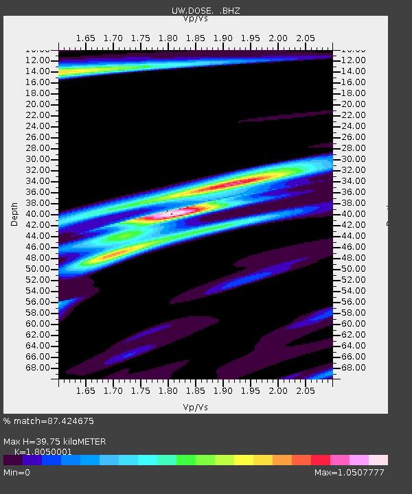
DOSE Dosewallips old TA.C04A, WA - Earthquake Result Viewer

Earthquake location: Near Coast Of Northern Peru
Earthquake latitude/longitude: -5.4/-81.9
Earthquake time(UTC): 2013/08/12 (224) 09:49:32 GMT
Earthquake Depth: 10 km
Earthquake Magnitude: 6.2 MWW, 6.1 MWB, 6.2 MWW, 6.2 MWC, 6.3 MWC
Earthquake Catalog/Contributor: NEIC PDE/NEIC COMCAT
Network: UW Pacific Northwest Regional Seismic Network
Station: DOSE Dosewallips old TA.C04A, WA
Lat/Lon: 47.72 N/122.97 W
Elevation: 53 m
Distance: 64.0 deg
Az: 330.444 deg
Baz: 133.339 deg
Ray Param: 0.05919885
Estimated Moho Depth: 39.75 km
Estimated Crust Vp/Vs: 1.81
Assumed Crust Vp: 6.566 km/s
Estimated Crust Vs: 3.638 km/s
Estimated Crust Poisson's Ratio: 0.28
Radial Match: 87.424675 %
Radial Bump: 283
Transverse Match: 83.2443 %
Transverse Bump: 400
SOD ConfigId: 626651
Insert Time: 2014-04-17 23:42:25.497 +0000
GWidth: 2.5
Max Bumps: 400
Tol: 0.001

Signal To Noise

ChannelStoNSTALTA
UW:DOSE: :BHZ:20130812T09:59:34.83998Z14.4008481.2190541E-68.4651546E-8
UW:DOSE: :BHN:20130812T09:59:34.83998Z6.87663565.9169275E-78.6043926E-8
UW:DOSE: :BHE:20130812T09:59:34.83998Z10.9555315.707656E-75.2098397E-8
Arrivals
Ps5.1 SECOND
PpPs16 SECOND
PsPs/PpSs21 SECOND