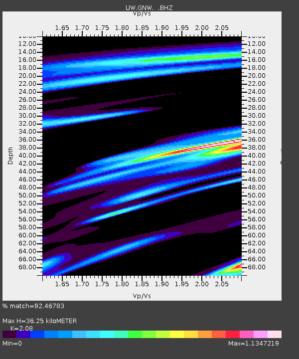
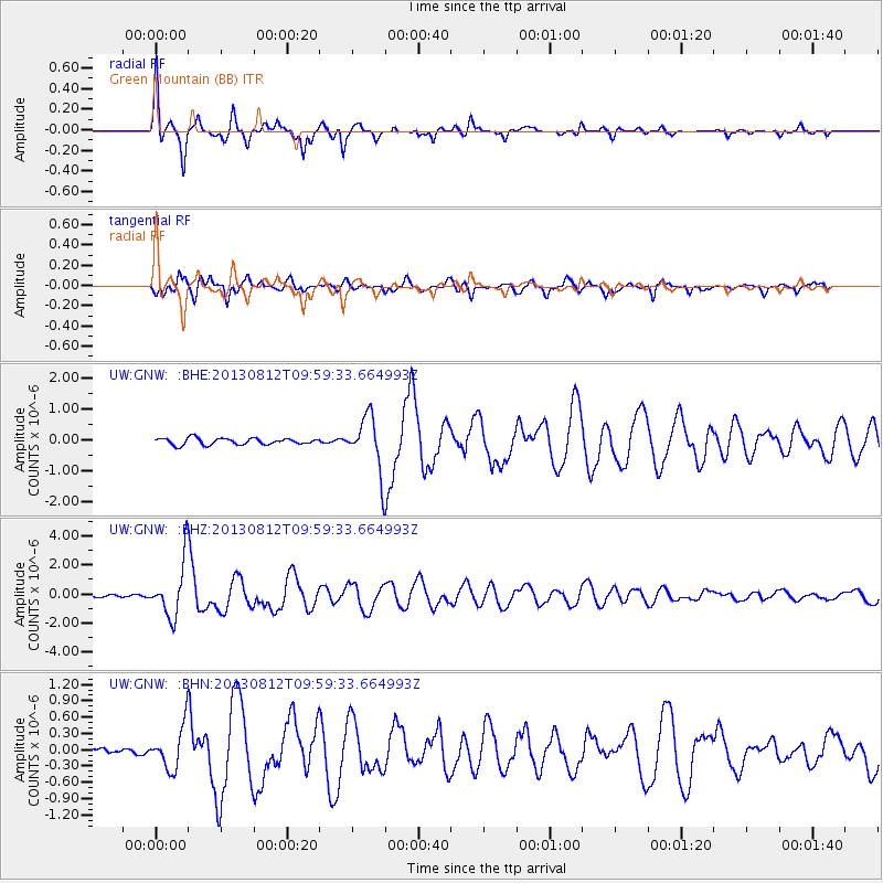
GNW Green Mountain (BB) - Earthquake Result Viewer

Earthquake location: Near Coast Of Northern Peru
Earthquake latitude/longitude: -5.4/-81.9
Earthquake time(UTC): 2013/08/12 (224) 09:49:32 GMT
Earthquake Depth: 10 km
Earthquake Magnitude: 6.2 MWW, 6.1 MWB, 6.2 MWW, 6.2 MWC, 6.3 MWC
Earthquake Catalog/Contributor: NEIC PDE/NEIC COMCAT
Network: UW Pacific Northwest Regional Seismic Network
Station: GNW Green Mountain (BB)
Lat/Lon: 47.56 N/122.83 W
Elevation: 160 m
Distance: 63.8 deg
Az: 330.396 deg
Baz: 133.426 deg
Ray Param: 0.05931629
Estimated Moho Depth: 36.25 km
Estimated Crust Vp/Vs: 2.08
Assumed Crust Vp: 6.566 km/s
Estimated Crust Vs: 3.157 km/s
Estimated Crust Poisson's Ratio: 0.35
Radial Match: 92.46783 %
Radial Bump: 335
Transverse Match: 80.074554 %
Transverse Bump: 400
SOD ConfigId: 626651
Insert Time: 2014-04-17 23:42:31.004 +0000
GWidth: 2.5
Max Bumps: 400
Tol: 0.001

Signal To Noise

ChannelStoNSTALTA
UW:GNW: :BHZ:20130812T09:59:33.664993Z27.6800371.8861858E-66.814246E-8
UW:GNW: :BHN:20130812T09:59:33.664993Z4.3059883.904491E-79.067585E-8
UW:GNW: :BHE:20130812T09:59:33.664993Z8.4375518.9088286E-71.05585485E-7
Arrivals
Ps6.2 SECOND
PpPs16 SECOND
PsPs/PpSs23 SECOND