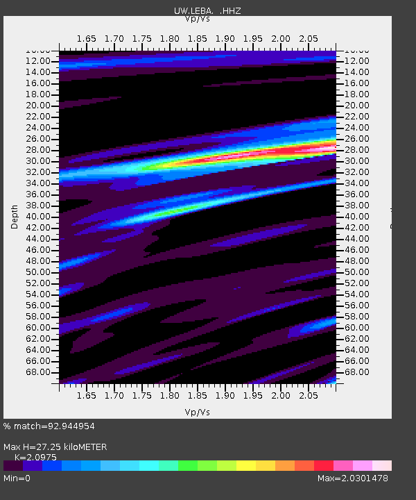
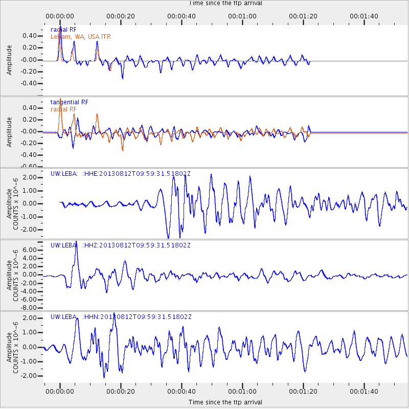
LEBA Lebam, WA, USA - Earthquake Result Viewer

Earthquake location: Near Coast Of Northern Peru
Earthquake latitude/longitude: -5.4/-81.9
Earthquake time(UTC): 2013/08/12 (224) 09:49:32 GMT
Earthquake Depth: 10 km
Earthquake Magnitude: 6.2 MWW, 6.1 MWB, 6.2 MWW, 6.2 MWC, 6.3 MWC
Earthquake Catalog/Contributor: NEIC PDE/NEIC COMCAT
Network: UW Pacific Northwest Regional Seismic Network
Station: LEBA Lebam, WA, USA
Lat/Lon: 46.55 N/123.56 W
Elevation: 73 m
Distance: 63.5 deg
Az: 329.18 deg
Baz: 132.348 deg
Ray Param: 0.059528146
Estimated Moho Depth: 27.25 km
Estimated Crust Vp/Vs: 2.10
Assumed Crust Vp: 6.566 km/s
Estimated Crust Vs: 3.13 km/s
Estimated Crust Poisson's Ratio: 0.35
Radial Match: 92.944954 %
Radial Bump: 400
Transverse Match: 79.73145 %
Transverse Bump: 400
SOD ConfigId: 626651
Insert Time: 2014-04-17 23:42:43.359 +0000
GWidth: 2.5
Max Bumps: 400
Tol: 0.001

Signal To Noise

ChannelStoNSTALTA
UW:LEBA: :HHZ:20130812T09:59:31.51802Z21.3321841.6676521E-67.8175404E-8
UW:LEBA: :HHN:20130812T09:59:31.51802Z2.81152844.7604135E-71.6931763E-7
UW:LEBA: :HHE:20130812T09:59:31.51802Z5.02868945.6714845E-71.1278256E-7
Arrivals
Ps4.7 SECOND
PpPs12 SECOND
PsPs/PpSs17 SECOND