You are here: Home > Network List > AK - Alaska Regional Network Stations List
> Station BAGL Bagley Icefield, AK, USA > Earthquake Result Viewer
BAGL Bagley Icefield, AK, USA - Earthquake Result Viewer
| Earthquake location: |
South Of Panama |
| Earthquake latitude/longitude: |
5.8/-78.2 |
| Earthquake time(UTC): |
2013/08/13 (225) 15:43:15 GMT |
| Earthquake Depth: |
12 km |
| Earthquake Magnitude: |
6.7 MWW, 6.6 MWB, 6.7 MWW, 6.7 MWC, 6.7 MI |
| Earthquake Catalog/Contributor: |
NEIC PDE/NEIC COMCAT |
|
| Network: |
AK Alaska Regional Network |
| Station: |
BAGL Bagley Icefield, AK, USA |
| Lat/Lon: |
60.49 N/142.09 W |
| Elevation: |
1470 m |
|
| Distance: |
72.3 deg |
| Az: |
332.186 deg |
| Baz: |
110.326 deg |
| Ray Param: |
0.053730834 |
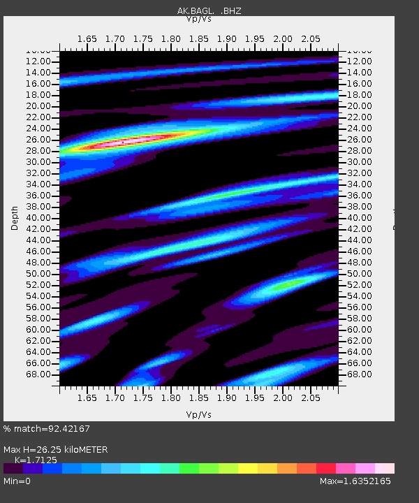
| Estimated Moho Depth: |
26.25 km |
| Estimated Crust Vp/Vs: |
1.71 |
| Assumed Crust Vp: |
6.566 km/s |
| Estimated Crust Vs: |
3.834 km/s |
| Estimated Crust Poisson's Ratio: |
0.24 |
|
| Radial Match: |
92.42167 % |
| Radial Bump: |
390 |
| Transverse Match: |
89.32467 % |
| Transverse Bump: |
400 |
| SOD ConfigId: |
626651 |
| Insert Time: |
2014-04-17 23:56:26.435 +0000 |
| GWidth: |
2.5 |
| Max Bumps: |
400 |
| Tol: |
0.001 |
|

Signal To Noise
| Channel | StoN | STA | LTA |
| AK:BAGL: :BHZ:20130813T15:54:09.36803Z | 19.05533 | 1.2176565E-6 | 6.3901105E-8 |
| AK:BAGL: :BHN:20130813T15:54:09.36803Z | 1.3534069 | 9.758712E-8 | 7.210478E-8 |
| AK:BAGL: :BHE:20130813T15:54:09.36803Z | 3.1113813 | 4.1432628E-7 | 1.3316475E-7 |
| Arrivals |
| Ps | 3.0 SECOND |
| PpPs | 10 SECOND |
| PsPs/PpSs | 13 SECOND |


