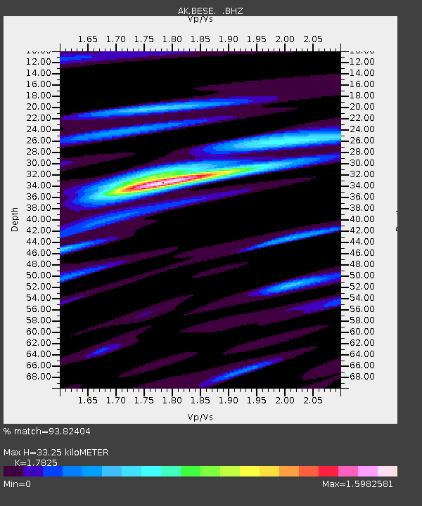
BESE Bessie Mountain - Earthquake Result Viewer

Earthquake location: South Of Panama
Earthquake latitude/longitude: 5.8/-78.2
Earthquake time(UTC): 2013/08/13 (225) 15:43:15 GMT
Earthquake Depth: 12 km
Earthquake Magnitude: 6.7 MWW, 6.6 MWB, 6.7 MWW, 6.7 MWC, 6.7 MI
Earthquake Catalog/Contributor: NEIC PDE/NEIC COMCAT
Network: AK Alaska Regional Network
Station: BESE Bessie Mountain
Lat/Lon: 58.58 N/134.85 W
Elevation: 870 m
Distance: 68.2 deg
Az: 331.876 deg
Baz: 116.451 deg
Ray Param: 0.056466304
Estimated Moho Depth: 33.25 km
Estimated Crust Vp/Vs: 1.78
Assumed Crust Vp: 6.566 km/s
Estimated Crust Vs: 3.684 km/s
Estimated Crust Poisson's Ratio: 0.27
Radial Match: 93.82404 %
Radial Bump: 330
Transverse Match: 85.07995 %
Transverse Bump: 400
SOD ConfigId: 626651
Insert Time: 2014-04-17 23:56:39.535 +0000
GWidth: 2.5
Max Bumps: 400
Tol: 0.001

Signal To Noise

ChannelStoNSTALTA
AK:BESE: :BHZ:20130813T15:53:44.067981Z16.899991.2710244E-67.52086E-8
AK:BESE: :BHN:20130813T15:53:44.067981Z2.23686174.3615077E-71.9498334E-7
AK:BESE: :BHE:20130813T15:53:44.067981Z4.7837895.5357424E-71.1571879E-7
Arrivals
Ps4.1 SECOND
PpPs14 SECOND
PsPs/PpSs18 SECOND