You are here: Home > Network List > CI - Caltech Regional Seismic Network Stations List
> Station TIN Tinemaha, California, USA > Earthquake Result Viewer
TIN Tinemaha, California, USA - Earthquake Result Viewer
| Earthquake location: |
Taiwan |
| Earthquake latitude/longitude: |
23.8/121.0 |
| Earthquake time(UTC): |
1999/09/20 (263) 17:47:18 GMT |
| Earthquake Depth: |
33 km |
| Earthquake Magnitude: |
6.5 MB, 7.7 MS, 7.7 MW, 7.2 ME |
| Earthquake Catalog/Contributor: |
WHDF/NEIC |
|
| Network: |
CI Caltech Regional Seismic Network |
| Station: |
TIN Tinemaha, California, USA |
| Lat/Lon: |
37.05 N/118.23 W |
| Elevation: |
1164 m |
|
| Distance: |
97.7 deg |
| Az: |
43.914 deg |
| Baz: |
307.414 deg |
| Ray Param: |
0.04010684 |
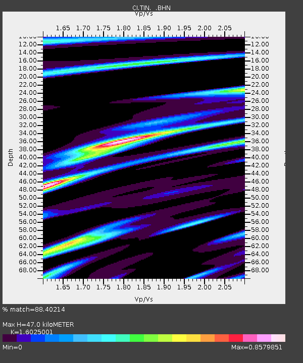
| Estimated Moho Depth: |
47.0 km |
| Estimated Crust Vp/Vs: |
1.60 |
| Assumed Crust Vp: |
6.291 km/s |
| Estimated Crust Vs: |
3.926 km/s |
| Estimated Crust Poisson's Ratio: |
0.18 |
|
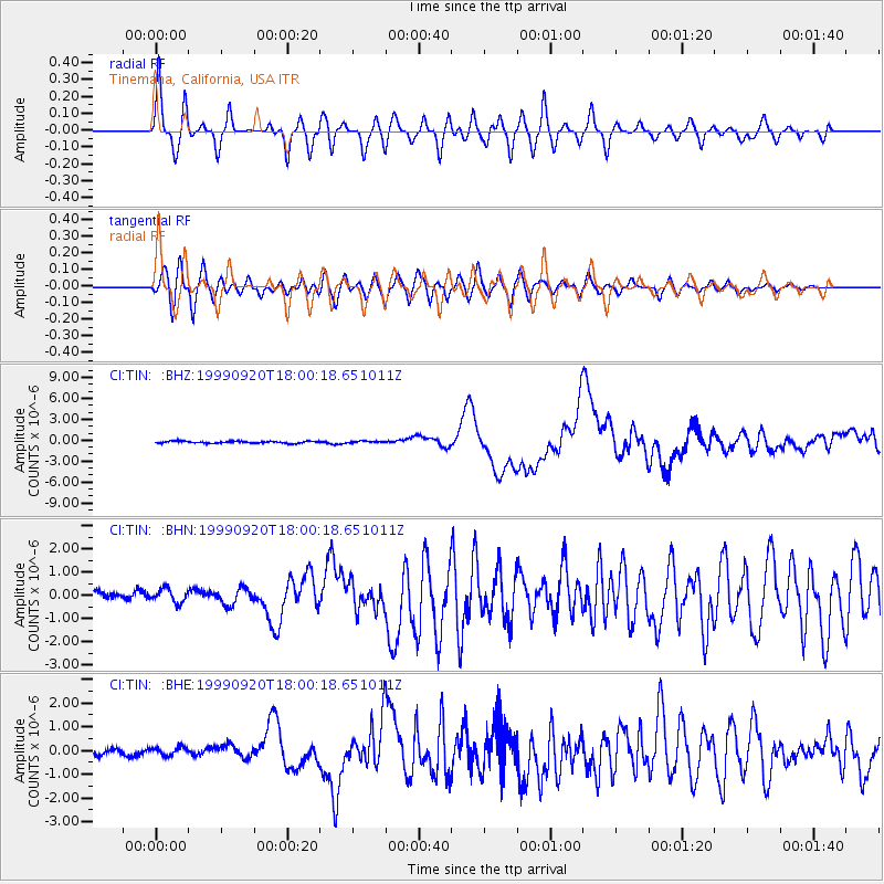
| Radial Match: |
88.40214 % |
| Radial Bump: |
400 |
| Transverse Match: |
84.275185 % |
| Transverse Bump: |
400 |
| SOD ConfigId: |
3787 |
| Insert Time: |
2010-02-25 20:49:43.915 +0000 |
| GWidth: |
2.5 |
| Max Bumps: |
400 |
| Tol: |
0.001 |
|
Signal To Noise
| Channel | StoN | STA | LTA |
| CI:TIN: :BHN:19990920T18:00:18.651011Z | 1.440136 | 3.1587024E-7 | 2.1933363E-7 |
| CI:TIN: :BHE:19990920T18:00:18.651011Z | 1.08081 | 2.0460472E-7 | 1.8930683E-7 |
| CI:TIN: :BHZ:19990920T18:00:18.651011Z | 0.9360181 | 1.3039418E-7 | 1.3930733E-7 |
| Arrivals |
| Ps | 4.6 SECOND |
| PpPs | 19 SECOND |
| PsPs/PpSs | 24 SECOND |


