You are here: Home > Network List > AZ - ANZA Regional Network Stations List
> Station SMER AZ.SMER > Earthquake Result Viewer
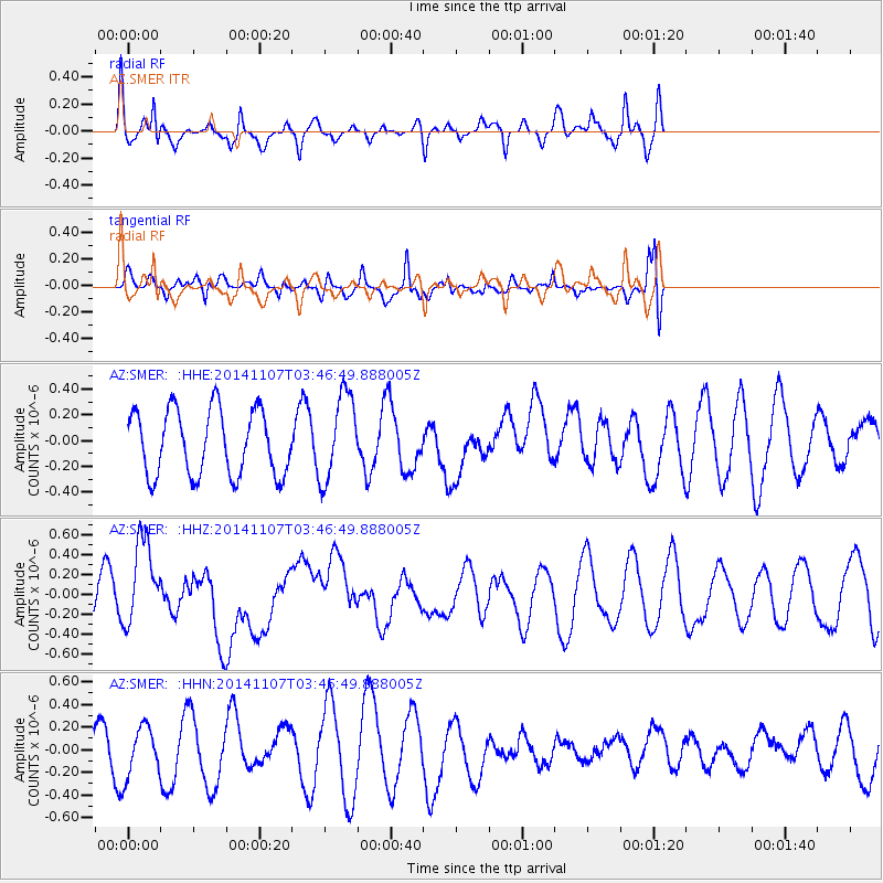
SMER AZ.SMER - Earthquake Result Viewer
*The percent match for this event was below the threshold and hence no stack was calculated.
| Earthquake location: |
New Britain Region, P.N.G. |
| Earthquake latitude/longitude: |
-6.0/148.2 |
| Earthquake time(UTC): |
2014/11/07 (311) 03:33:54 GMT |
| Earthquake Depth: |
43 km |
| Earthquake Magnitude: |
6.6 MWW, 6.6 MWB, 6.9 MI |
| Earthquake Catalog/Contributor: |
NEIC PDE/NEIC COMCAT |
|
| Network: |
AZ ANZA Regional Network |
| Station: |
SMER AZ.SMER |
| Lat/Lon: |
33.46 N/117.17 W |
| Elevation: |
355 m |
|
| Distance: |
97.1 deg |
| Az: |
57.118 deg |
| Baz: |
267.488 deg |
| Ray Param: |
$rayparam |
*The percent match for this event was below the threshold and hence was not used in the summary stack. |
|
| Radial Match: |
79.762535 % |
| Radial Bump: |
351 |
| Transverse Match: |
58.477585 % |
| Transverse Bump: |
400 |
| SOD ConfigId: |
3390531 |
| Insert Time: |
2019-04-14 21:05:34.310 +0000 |
| GWidth: |
2.5 |
| Max Bumps: |
400 |
| Tol: |
0.001 |
|
Signal To Noise
| Channel | StoN | STA | LTA |
| AZ:SMER: :HHZ:20141107T03:46:49.888005Z | 2.264506 | 4.3199265E-7 | 1.9076684E-7 |
| AZ:SMER: :HHN:20141107T03:46:49.888005Z | 1.4673685 | 2.1809326E-7 | 1.4862883E-7 |
| AZ:SMER: :HHE:20141107T03:46:49.888005Z | 1.2126971 | 3.0511097E-7 | 2.51597E-7 |
| Arrivals |
| Ps | |
| PpPs | |
| PsPs/PpSs | |


