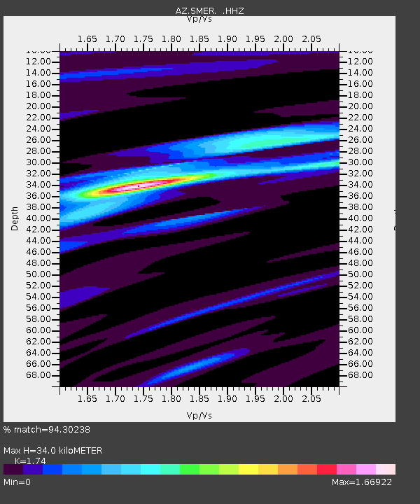
SMER AZ.SMER - Earthquake Result Viewer
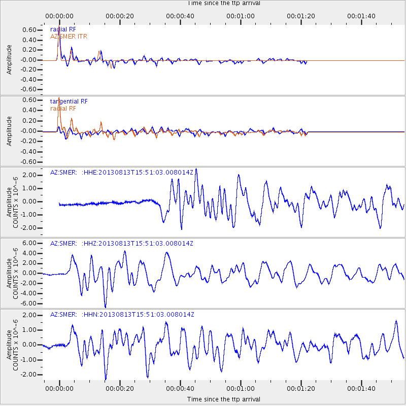
Earthquake location: South Of Panama
Earthquake latitude/longitude: 5.8/-78.2
Earthquake time(UTC): 2013/08/13 (225) 15:43:15 GMT
Earthquake Depth: 12 km
Earthquake Magnitude: 6.7 MWW, 6.6 MWB, 6.7 MWW, 6.7 MWC, 6.7 MI
Earthquake Catalog/Contributor: NEIC PDE/NEIC COMCAT
Network: AZ ANZA Regional Network
Station: SMER AZ.SMER
Lat/Lon: 33.46 N/117.17 W
Elevation: 355 m
Distance: 45.4 deg
Az: 312.457 deg
Baz: 118.584 deg
Ray Param: 0.0712649
Estimated Moho Depth: 34.0 km
Estimated Crust Vp/Vs: 1.74
Assumed Crust Vp: 6.264 km/s
Estimated Crust Vs: 3.6 km/s
Estimated Crust Poisson's Ratio: 0.25
Radial Match: 94.30238 %
Radial Bump: 292
Transverse Match: 73.349174 %
Transverse Bump: 400
SOD ConfigId: 626651
Insert Time: 2014-04-18 00:01:52.121 +0000
GWidth: 2.5
Max Bumps: 400
Tol: 0.001

Signal To Noise

ChannelStoNSTALTA
AZ:SMER: :HHZ:20130813T15:51:03.008014Z18.8373221.4752146E-67.831339E-8
AZ:SMER: :HHN:20130813T15:51:03.008014Z3.355925.2881325E-71.5757624E-7
AZ:SMER: :HHE:20130813T15:51:03.008014Z6.5142855.571657E-78.5529834E-8
Arrivals
Ps4.3 SECOND
PpPs14 SECOND
PsPs/PpSs18 SECOND